Security News
Research
Data Theft Repackaged: A Case Study in Malicious Wrapper Packages on npm
The Socket Research Team breaks down a malicious wrapper package that uses obfuscation to harvest credentials and exfiltrate sensitive data.

Create STAC Items from raster datasets.
Documentation: https://developmentseed.github.io/rio-stac/
Source Code: https://github.com/developmentseed/rio-stac
rio-stac is a simple rasterio plugin for creating valid STAC items from a raster dataset. The library is built on top of pystac to make sure we follow the STAC specification.
$ pip install pip -U

# From Pypi
$ pip install rio-stac

# Or from source
$ pip install git+http://github.com/developmentseed/rio-stac
// rio stac tests/fixtures/dataset_cog.tif | jq
{
  "type": "Feature",
  "stac_version": "1.0.0",
  "id": "dataset_cog.tif",
  "properties": {
    "proj:epsg": 32621,
    "proj:geometry": {
      "type": "Polygon",
      "coordinates": [
        [
          [
            373185.0,
            8019284.949381611
          ],
          [
            639014.9492102272,
            8019284.949381611
          ],
          [
            639014.9492102272,
            8286015.0
          ],
          [
            373185.0,
            8286015.0
          ],
          [
            373185.0,
            8019284.949381611
          ]
        ]
      ]
    },
    "proj:bbox": [
      373185.0,
      8019284.949381611,
      639014.9492102272,
      8286015.0
    ],
    "proj:shape": [
      2667,
      2658
    ],
    "proj:transform": [
      100.01126757344893,
      0.0,
      373185.0,
      0.0,
      -100.01126757344893,
      8286015.0,
      0.0,
      0.0,
      1.0
    ],
    "proj:projjson": {
      "$schema": "https://proj.org/schemas/v0.4/projjson.schema.json",
      "type": "ProjectedCRS",
      "name": "WGS 84 / UTM zone 21N",
      "base_crs": {
        "name": "WGS 84",
        "datum": {
          "type": "GeodeticReferenceFrame",
          "name": "World Geodetic System 1984",
          "ellipsoid": {
            "name": "WGS 84",
            "semi_major_axis": 6378137,
            "inverse_flattening": 298.257223563
          }
        },
        "coordinate_system": {
          "subtype": "ellipsoidal",
          "axis": [
            {
              "name": "Geodetic latitude",
              "abbreviation": "Lat",
              "direction": "north",
              "unit": "degree"
            },
            {
              "name": "Geodetic longitude",
              "abbreviation": "Lon",
              "direction": "east",
              "unit": "degree"
            }
          ]
        },
        "id": {
          "authority": "EPSG",
          "code": 4326
        }
      },
      "conversion": {
        "name": "UTM zone 21N",
        "method": {
          "name": "Transverse Mercator",
          "id": {
            "authority": "EPSG",
            "code": 9807
          }
        },
        "parameters": [
          {
            "name": "Latitude of natural origin",
            "value": 0,
            "unit": "degree",
            "id": {
              "authority": "EPSG",
              "code": 8801
            }
          },
          {
            "name": "Longitude of natural origin",
            "value": -57,
            "unit": "degree",
            "id": {
              "authority": "EPSG",
              "code": 8802
            }
          },
          {
            "name": "Scale factor at natural origin",
            "value": 0.9996,
            "unit": "unity",
            "id": {
              "authority": "EPSG",
              "code": 8805
            }
          },
          {
            "name": "False easting",
            "value": 500000,
            "unit": "metre",
            "id": {
              "authority": "EPSG",
              "code": 8806
            }
          },
          {
            "name": "False northing",
            "value": 0,
            "unit": "metre",
            "id": {
              "authority": "EPSG",
              "code": 8807
            }
          }
        ]
      },
      "coordinate_system": {
        "subtype": "Cartesian",
        "axis": [
          {
            "name": "Easting",
            "abbreviation": "",
            "direction": "east",
            "unit": "metre"
          },
          {
            "name": "Northing",
            "abbreviation": "",
            "direction": "north",
            "unit": "metre"
          }
        ]
      },
      "id": {
        "authority": "EPSG",
        "code": 32621
      }
    },
    "proj:wkt2": "PROJCS[\"WGS 84 / UTM zone 21N\",GEOGCS[\"WGS 84\",DATUM[\"WGS_1984\",SPHEROID[\"WGS 84\",6378137,298.257223563,AUTHORITY[\"EPSG\",\"7030\"]],AUTHORITY[\"EPSG\",\"6326\"]],PRIMEM[\"Greenwich\",0,AUTHORITY[\"EPSG\",\"8901\"]],UNIT[\"degree\",0.0174532925199433,AUTHORITY[\"EPSG\",\"9122\"]],AUTHORITY[\"EPSG\",\"4326\"]],PROJECTION[\"Transverse_Mercator\"],PARAMETER[\"latitude_of_origin\",0],PARAMETER[\"central_meridian\",-57],PARAMETER[\"scale_factor\",0.9996],PARAMETER[\"false_easting\",500000],PARAMETER[\"false_northing\",0],UNIT[\"metre\",1,AUTHORITY[\"EPSG\",\"9001\"]],AXIS[\"Easting\",EAST],AXIS[\"Northing\",NORTH],AUTHORITY[\"EPSG\",\"32621\"]]",
    "datetime": "2023-12-08T09:30:38.153261Z"
  },
  "geometry": {
    "type": "Polygon",
    "coordinates": [
      [
        [
          -60.72634617297825,
          72.23689137791739
        ],
        [
          -52.91627525610924,
          72.22979795551834
        ],
        [
          -52.301598718454485,
          74.61378388950398
        ],
        [
          -61.28762442711404,
          74.62204314252978
        ],
        [
          -60.72634617297825,
          72.23689137791739
        ]
      ]
    ]
  },
  "links": [],
  "assets": {
    "asset": {
      "href": "/Users/vincentsarago/Dev/DevSeed/rio-stac/tests/fixtures/dataset_cog.tif",
      "raster:bands": [
        {
          "data_type": "uint16",
          "scale": 1.0,
          "offset": 0.0,
          "sampling": "point",
          "statistics": {
            "mean": 2107.524612053134,
            "minimum": 1,
            "maximum": 7872,
            "stddev": 2271.0065537857326,
            "valid_percent": 0.00009564764936336924
          },
          "histogram": {
            "count": 11,
            "min": 1.0,
            "max": 7872.0,
            "buckets": [
              503460,
              0,
              0,
              161792,
              283094,
              0,
              0,
              0,
              87727,
              9431
            ]
          }
        }
      ],
      "eo:bands": [
        {
          "name": "b1",
          "description": "gray"
        }
      ],
      "roles": []
    }
  },
  "bbox": [
    -61.28762442711404,
    72.22979795551834,
    -52.301598718454485,
    74.62204314252978
  ],
  "stac_extensions": [
    "https://stac-extensions.github.io/projection/v1.1.0/schema.json",
    "https://stac-extensions.github.io/raster/v1.1.0/schema.json",
    "https://stac-extensions.github.io/eo/v1.1.0/schema.json"
  ]
}
See https://developmentseed.org/rio-stac/intro/ for more.
See CONTRIBUTING.md
See contributors
See CHANGES.md.
See LICENSE
FAQs
Create STAC Items from raster datasets.
We found that rio-stac demonstrated a healthy version release cadence and project activity because the last version was released less than a year ago. It has 2 open source maintainers collaborating on the project.
Did you know?

Socket for GitHub automatically highlights issues in each pull request and monitors the health of all your open source dependencies. Discover the contents of your packages and block harmful activity before you install or update your dependencies.

Security News
Research
The Socket Research Team breaks down a malicious wrapper package that uses obfuscation to harvest credentials and exfiltrate sensitive data.

Research
Security News
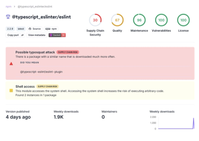
Attackers used a malicious npm package typosquatting a popular ESLint plugin to steal sensitive data, execute commands, and exploit developer systems.

Security News
The Ultralytics' PyPI Package was compromised four times in one weekend through GitHub Actions cache poisoning and failure to rotate previously compromised API tokens.