Research
Malicious npm Packages Impersonate Flashbots SDKs, Targeting Ethereum Wallet Credentials
Four npm packages disguised as cryptographic tools steal developer credentials and send them to attacker-controlled Telegram infrastructure.
github.com/flopp/go-staticmaps
A go (golang) library and command line tool to render static map images using OpenStreetMap tiles.
go-staticmaps is a golang library that allows you to create nice static map images from OpenStreetMap tiles, along with markers of different size and color, as well as paths and colored areas.
For a Python version with a similar interface, take a look at py-staticmaps.
go-staticmaps comes with a command line tool called create-static-map for use in shell scripts, etc.

Installing go-staticmaps is as easy as
go get -u github.com/flopp/go-staticmaps
For the command line tool, use
go get -u github.com/flopp/go-staticmaps/create-static-map
Of course, your local Go installation must be setup up properly.
Create a 400x300 pixel map with a red marker:
package main

import (
  "image/color"

  sm "github.com/flopp/go-staticmaps"
  "github.com/fogleman/gg"
  "github.com/golang/geo/s2"
)

func main() {
  ctx := sm.NewContext()
  ctx.SetSize(400, 300)
	ctx.SetZoom(14)
  ctx.AddObject(
    sm.NewMarker(
      s2.LatLngFromDegrees(52.514536, 13.350151),
      color.RGBA{0xff, 0, 0, 0xff},
      16.0,
    ),
  )

  img, err := ctx.Render()
  if err != nil {
    panic(err)
  }

  if err := gg.SavePNG("my-map.png", img); err != nil {
    panic(err)
  }
}
See PkgGoDev for a complete documentation and the source code of the command line tool for an example how to use the package.
Usage:
  create-static-map [OPTIONS]

Creates a static map

Application Options:
      --width=PIXELS              Width of the generated static map image (default: 512)
      --height=PIXELS             Height of the generated static map image (default: 512)
  -o, --output=FILENAME           Output file name (default: map.png)
  -t, --type=MAPTYPE              Select the map type; list possible map types with '--type list'
  -c, --center=LATLNG             Center coordinates (lat,lng) of the static map
  -z, --zoom=ZOOMLEVEL            Zoom factor
  -b, --bbox=nwLATLNG|seLATLNG    Bounding box of the static map
      --background=COLOR          Background color (default: transparent)
  -u, --useragent=USERAGENT       Overwrite the default HTTP user agent string
  -m, --marker=MARKER             Add a marker to the static map
  -i, --imagemarker=MARKER        Add an image marker to the static map
  -p, --path=PATH                 Add a path to the static map
  -a, --area=AREA                 Add an area to the static map
  -C, --circle=CIRCLE             Add a circle to the static map

Help Options:
  -h, --help                      Show this help message
The command line interface tries to resemble Google's Static Maps API.
If neither --bbox, --center, nor --zoom are given, the map extent is determined from the specified markers, paths and areas.
--background lets you specify a color used for map areas that are not covered by map tiles (areas north of 85°/south of -85°).
The --marker option defines one or more map markers of the same style. Use multiple --marker options to add markers of different styles.
--marker MARKER_STYLES|LATLNG|LATLNG|...
LATLNG is a comma separated pair of latitude and longitude, e.g. 52.5153,13.3564.
MARKER_STYLES consists of a set of style descriptors separated by the pipe character |:
color:COLOR - where COLOR is either of the form 0xRRGGBB, 0xRRGGBBAA, or one of black, blue, brown, green, orange, purple, red, yellow, white (default: red)size:SIZE - where SIZE is one of mid, small, tiny, or some number > 0 (default: mid)label:LABEL - where LABEL is an alpha numeric character, i.e. A-Z, a-z, 0-9; (default: no label)labelcolor:COLOR - where COLOR is either of the form 0xRRGGBB, 0xRRGGBBAA, or one of black, blue, brown, green, orange, purple, red, yellow, white (default: black or white, depending on the marker color)Using the --imagemarker option, you can use custom images as markers:
--imagemarker image:IMAGEFILE|offsetx:OFFSETX|offsety:OFFSETY|LATLNG|LATLNG|...
IMAGEFILE is the file name of a PNG or JPEG file,
OFFSETX and OFFSETY are the pixel offsets of the reference point from the top-left corner of the image.
The --path option defines a path on the map. Use multiple --path options to add multiple paths to the map.
--path PATH_STYLES|LATLNG|LATLNG|...
or
--path PATH_STYLES|gpx:my_gpx_file.gpx
PATH_STYLES consists of a set of style descriptors separated by the pipe character |:
color:COLOR - where COLOR is either of the form 0xRRGGBB, 0xRRGGBBAA, or one of black, blue, brown, green, orange, purple, red, yellow, white (default: red)weight:WEIGHT - where WEIGHT is the line width in pixels (defaut: 5)The --area option defines a closed area on the map. Use multiple --area options to add multiple areas to the map.
--area AREA_STYLES|LATLNG|LATLNG|...
AREA_STYLES consists of a set of style descriptors separated by the pipe character |:
color:COLOR - where COLOR is either of the form 0xRRGGBB, 0xRRGGBBAA, or one of black, blue, brown, green, orange, purple, red, yellow, white (default: red)weight:WEIGHT - where WEIGHT is the line width in pixels (defaut: 5)fill:COLOR - where COLOR is either of the form 0xRRGGBB, 0xRRGGBBAA, or one of black, blue, brown, green, orange, purple, red, yellow, white (default: none)The --circles option defines one or more circles of the same style. Use multiple --circle options to add circles of different styles.
--circle CIRCLE_STYLES|LATLNG|LATLNG|...
LATLNG is a comma separated pair of latitude and longitude, e.g. 52.5153,13.3564.
CIRCLE_STYLES consists of a set of style descriptors separated by the pipe character |:
color:COLOR - where COLOR is either of the form 0xRRGGBB, 0xRRGGBBAA, or one of black, blue, brown, green, orange, purple, red, yellow, white (default: red)fill:COLOR - where COLOR is either of the form 0xRRGGBB, 0xRRGGBBAA, or one of black, blue, brown, green, orange, purple, red, yellow, white (default: no fill color)radius:RADIUS - where RADIUS is te circle radius in meters (default: 100.0)weight:WEIGHT - where WEIGHT is the line width in pixels (defaut: 5)Centered at "N 52.514536 E 13.350151" with zoom level 10:
$ create-static-map --width 600 --height 400 -o map1.png -c "52.514536,13.350151" -z 10

A map with a marker at "N 52.514536 E 13.350151" with zoom level 14 (no need to specify the map's center - it is automatically computed from the marker(s)):
$ create-static-map --width 600 --height 400 -o map2.png -z 14 -m "52.514536,13.350151"

A map with two markers (red and green). If there are more than two markers in the map, a good zoom level can be determined automatically:
$ create-static-map --width 600 --height 400 -o map3.png -m "color:red|52.514536,13.350151" -m "color:green|52.516285,13.377746"

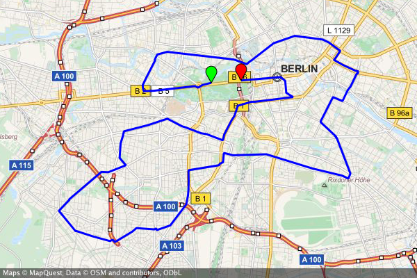
create-static-map --width 800 --height 600 \
  --marker "color:green|52.5153,13.3564" \
  --marker "color:red|52.5160,13.3711" \
  --output "berlin-marathon.png" \
  --path "color:blue|weight:2|gpx:berlin-marathon.gpx"

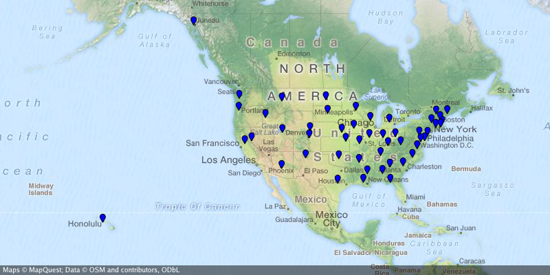
create-static-map --width 800 --height 400 \
  --output "us-capitals.png" \
  --marker "color:blue|size:tiny|32.3754,-86.2996|58.3637,-134.5721|33.4483,-112.0738|34.7244,-92.2789|\
    38.5737,-121.4871|39.7551,-104.9881|41.7665,-72.6732|39.1615,-75.5136|30.4382,-84.2806|33.7545,-84.3897|\
    21.2920,-157.8219|43.6021,-116.2125|39.8018,-89.6533|39.7670,-86.1563|41.5888,-93.6203|39.0474,-95.6815|\
    38.1894,-84.8715|30.4493,-91.1882|44.3294,-69.7323|38.9693,-76.5197|42.3589,-71.0568|42.7336,-84.5466|\
    44.9446,-93.1027|32.3122,-90.1780|38.5698,-92.1941|46.5911,-112.0205|40.8136,-96.7026|39.1501,-119.7519|\
    43.2314,-71.5597|40.2202,-74.7642|35.6816,-105.9381|42.6517,-73.7551|35.7797,-78.6434|46.8084,-100.7694|\
    39.9622,-83.0007|35.4931,-97.4591|44.9370,-123.0272|40.2740,-76.8849|41.8270,-71.4087|34.0007,-81.0353|\
    44.3776,-100.3177|36.1589,-86.7821|30.2687,-97.7452|40.7716,-111.8882|44.2627,-72.5716|37.5408,-77.4339|\
    47.0449,-122.9016|38.3533,-81.6354|43.0632,-89.4007|41.1389,-104.8165"

...where the Northern Territory is highlighted and the capital Canberra is marked.
create-static-map --width 800 --height 600 \
  --center="-26.284973,134.303764" \
  --output "australia.png" \
  --marker "color:blue|-35.305200,149.121574" \
  --area "color:0x00FF00|fill:0x00FF007F|weight:2|-25.994024,129.013847|-25.994024,137.989677|-16.537670,138.011649|\
    -14.834820,135.385917|-12.293236,137.033866|-11.174554,130.398124|-12.925791,130.167411|-14.866678,129.002860"

Besides the go standard library, go-staticmaps uses
RenderWithBounds functionNewArea and NewPath functionsCopyright 2016, 2017 Florian Pigorsch & Contributors. All rights reserved.
Use of this source code is governed by a MIT-style license that can be found in the LICENSE file.
FAQs
Unknown package
Did you know?

Socket for GitHub automatically highlights issues in each pull request and monitors the health of all your open source dependencies. Discover the contents of your packages and block harmful activity before you install or update your dependencies.

Research
Four npm packages disguised as cryptographic tools steal developer credentials and send them to attacker-controlled Telegram infrastructure.

Security News
Ruby maintainers from Bundler and rbenv teams are building rv to bring Python uv's speed and unified tooling approach to Ruby development.

Security News
Following last week’s supply chain attack, Nx published findings on the GitHub Actions exploit and moved npm publishing to Trusted Publishers.