Product
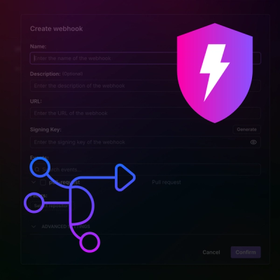
Introducing Webhook Events for Pull Request Scans
Add real-time Socket webhook events to your workflows to automatically receive pull request scan results and security alerts in real time.
By Jeppe Hasseriis - Oct 22, 2025
@gisatcz/ptr-tile-grid
Advanced tools
Tile grid for globe.
Tile grid covers the whole globe. Extent of grid is [bottomLeft, topRight] [[-180,-90], [180, 90]].
It is possible to generate all tiles for a certain level. Zero lavel has two tiles. Tiles count rise quadratic with each level.
Function getGridForLevelAndExtent(level, extent) creates grid for asked level and extent. Extent parameter is optional and use whole globe as default.
import {getSizeForLevel} from './src/grid';
const grid0 = getGridForLevelAndExtent(0);
//[
// [[-180,-90], [0,-90]]
//]
const grid1 = getGridForLevelAndExtent(1);
//[
// [[-180,0], [-90,0], [0,0], [90,0]],
// [[-180,-90], [-90,-90], [0,-90], [90,-90]]
//]
const grid2 = getGridForLevelAndExtent(2);
//[
// [[-180,45], [-135,45], [-90,45], [-45,45], [0,45], [45,45], [90,45], [135,45]],
// [[-180,0], [-135,0], [-90,0], [-45,0], [0,0], [45,0], [90,0], [135,0]],
// [[-180,-45], [-135,-45], [-90,-45], [-45,-45], [0,-45], [45,-45], [90,-45], [135,-45]],
// [[-180,-90], [-135,-90], [-90,-90], [-45,-90], [0,-90], [45,-90], [90,-90], [135,-90]]
// ]
import {getSizeForLevel} from './src/grid';

const grid2 = utils.getGridForLevelAndExtent(2, [
	[-10, -10],
	[10, 10],
]);
// [
//   [[-45,0], [0,0]],
//   [[-45,-45], [0,-45]
// ]
Tile is spherical square with same side size in degrees. Side size is same for all tiles in same level. Each tile is defined by left bottom (south west) corner longitude latitude.
import {getSizeForLevel} from './src/grid';

const level0 = getSizeForLevel(0); //180
const level1 = getSizeForLevel(1); //90
const level2 = getSizeForLevel(2); //45
const level3 = getSizeForLevel(3); //22.5
const level4 = getSizeForLevel(4); //11.25
const level5 = getSizeForLevel(5); //5.625
const level6 = getSizeForLevel(6); //2.8125
const level7 = getSizeForLevel(7); //1.40625
const level8 = getSizeForLevel(8); //0.703125
const level9 = getSizeForLevel(9); //0.3515625
const level10 = getSizeForLevel(10); //0.17578125
Tile set is defined by pyramid of levels, where each next level has quadratically more tile than level before.
Base level is level 0 with two tiles and side size 180°.
Level is required parameter for function getGridForLevelAndExtent. Usual usecase how determinate right level is by getLevelByViewport(boxRange, viewportRange) , where boxrange is smaller size of visible map in meters and viewportRange is smaller size of viewport in pixels.
import {getLevelByViewport} from './src/grid';

const boxRange = 240; //meters
const viewport = 240; //pixels

const level0 = grid.getLevelByViewport(boxRange, viewport);
// level0 = 17

const level1 = grid.getLevelByViewport(50000000, 250);
// level1 = 0
FAQs
Panther globe tile set in WGS84.
We found that @gisatcz/ptr-tile-grid demonstrated a not healthy version release cadence and project activity because the last version was released a year ago. It has 5 open source maintainers collaborating on the project.
Did you know?

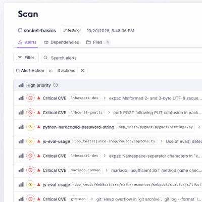
Socket for GitHub automatically highlights issues in each pull request and monitors the health of all your open source dependencies. Discover the contents of your packages and block harmful activity before you install or update your dependencies.
Product
Add real-time Socket webhook events to your workflows to automatically receive pull request scan results and security alerts in real time.

Research
The Socket Threat Research Team uncovered malicious NuGet packages typosquatting the popular Nethereum project to steal wallet keys.
Product
A single platform for static analysis, secrets detection, container scanning, and CVE checks—built on trusted open source tools, ready to run out of the box.