


Product
Announcing Bun and vlt Support in Socket
Bringing supply chain security to the next generation of JavaScript package managers
By Ricky Reusser, Eli Insua - Nov 19, 2025
@surbowl/world-geo-json-zh
Advanced tools
A simplified Chinese world map in GeoJSON format, including ISO 3166 codes, Chinese short names, and full names of countries (regions). 简体中文 GeoJson 世界地图,带有国家地区的 ISO 3166 代码、中文简称与全称

简体中文 Geo JSON 世界地图,带有国家(地区)的 ISO 3166 代码、中文简称与全称。含中国南海海域十段线。
A simplified Chinese world map in GeoJSON format, including ISO 3166 codes, Chinese short names, and full names of countries (regions). Contains China's Ten-Dash Line.
🌏 Data
👀 Demo
方式 1. js module
<script type="module">
import worldGeoJsonZh from 'https://cdn.jsdelivr.net/npm/@surbowl/world-geo-json-zh/+esm'
</script>
方式 2. npm
npm i @surbowl/world-geo-json-zh
JSON 格式
{
   "type": "FeatureCollection",
   "features": [
      {
         "type": "Feature",
         "properties": {
            "name": "中国",
            "full_name": "中华人民共和国",
            "iso_a2": "CN",   // ISO 3166 Alpha-2 code
            "iso_a3": "CHN",  // ISO 3166 Alpha-3 code
            "iso_n3": "156"   // ISO 3166 Numeric code
         },
         "geometry": {
            "type": "MultiPolygon",
            "coordinates": [ ...... ]
         }
      },
      {
         "type": "Feature",
         "properties": {
            "name": "智利",
            "full_name": "智利共和国",
            "iso_a2": "CL",
            "iso_a3": "CHL",
            "iso_n3": "152"
         },
         "geometry": {
            "type": "MultiPolygon",
            "coordinates": [ ...... ]
         }
      },

      ......

   ]
}
来源
本项目基于 Natural Earth 1:50m Cultural Vectors Admin 0 – Countries 地图生成。为降低文件体积,使用 Mapshaper 以 Douglas-Peucker 算法进行简化处理(-simplify dp 10% keep-shapes),Polygon 坐标精确到小数点后 6 位。并参照下列地图对结果进行调整:
注意事项
如需区分中国内地、中国香港、中国澳门、中国台湾,请查看 Issue 《有没有内地和港澳台四个单独拿出来绘制的版本呢》 ,或参考带注释的 JSONC 文件
国际标准化组织尚未制定下列国家(地区)的 ISO 3166 代码,无法通过 ISO 3166 代码匹配到下列国家(地区),您可根据业务需要将 -99 替换为自定义值。
| name | iso_a2 | iso_a3 | iso_n3 |
|---|---|---|---|
| 北塞浦路斯 | -99 | -99 | -99 |
| 索马里兰 | -99 | -99 | -99 |
| 锡亚琴冰川 | -99 | -99 | -99 |
引用
欢迎大家在 Issues 中提供建议、反馈问题❤
FAQs
A simplified Chinese world map in GeoJSON format, including ISO 3166 codes, Chinese short names, and full names of countries (regions). 简体中文 GeoJson 世界地图,带有国家地区的 ISO 3166 代码、中文简称与全称
We found that @surbowl/world-geo-json-zh demonstrated a healthy version release cadence and project activity because the last version was released less than a year ago. It has 1 open source maintainer collaborating on the project.
Did you know?

Socket for GitHub automatically highlights issues in each pull request and monitors the health of all your open source dependencies. Discover the contents of your packages and block harmful activity before you install or update your dependencies.
Product
Bringing supply chain security to the next generation of JavaScript package managers
Product
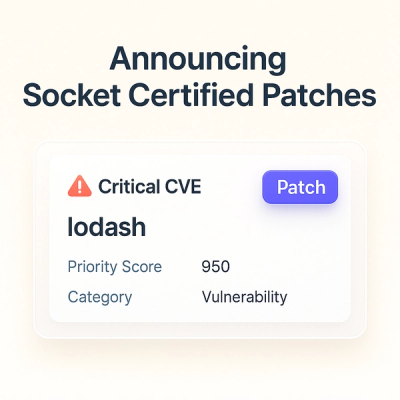
A safer, faster way to eliminate vulnerabilities without updating dependencies
Product
Reachability analysis for Ruby is now in beta, helping teams identify which vulnerabilities are truly exploitable in their applications.