Security News
Package Maintainers Call for Improvements to GitHub’s New npm Security Plan
Maintainers back GitHub’s npm security overhaul but raise concerns about CI/CD workflows, enterprise support, and token management.
wpify-mapy-cz-legacy
Advanced tools
This library works with standard Mapy.cz API, but it's nicer and more easy-to-use. However, the only minor API capabilities are not implemented and it can be used to advanced mapy.cz scenarios.
The map is loaded asynchonously, so it won't break your page speed indexes. It's built with page speed in mind.
The library can be used on any website. You can find example WordPress plugin with implementation here: https://gitlab.com/wpify/test-mapy-cz
npm install wpify-mapy-cz --save
or
yarn add wpify-mapy-cz
import { load, MapyCz } from 'wpify-mapy-cz';

// Setup configuration object
const config = {
  element: document.getElementById('some-map-div-id'), // this is only required parameter
  center: { latitude: 50.11968806014661, longitude: 14.42896842864991 },
  zoom: 13,
};

// 1: Load the map with callback function

load(config, (mapycz) => {
  // some map manipulation after load on callback
});

// 2: or with Premise

const mapycz = new MapyCz(config);
mapycz.resolver.then(mapycz => {
  // some map manipulation after load in Promise
});

// 3: or with async
const mapycz = new MapyCz(config);
await mapycz.resolver;
// some map manipulation

// 4: or in case you need to configure the map on the first render without further manipulations

load(config);
element: domelement, required; Element where you want to render the maplang: string; Language in the map. Accepts any of cs, en, de, sk, plmapType: string; Type of the map; default DEF_BASEapi: string; Loads full or simple map; default fullcenter: object; Center of the map in the { longitude: 0, latitude: 0 } format; default { longitude: 0, latitude: 0 }zoom: number; Zoom level; default 13default_controls: boolean; If true, adds default map controlssync_control: boolean; If true, synchronizes the map with element size changesmarkers: array; Adds multiple markers (see the marker format bellow)marker: object; Adds a marker (see the marker format bellow)auto_center_zoom: bool; Set the center and zoom to fit the markersclusterers: string|array|boolean; Sets the clusterer to the marker layer(s)poi: boolean; Show points of interestmap_type_switch: array|boolean; Shows the map type switcher. Accepts boolean or array of map typesimage_overlay: array|object; Sets the image overlay. Accepts array of overlays or overlay definitiongpx: array|object; Sets the GPX. Accepts array of GPXs or single GPX definitionconst config = {
element: document.getElementById('some-map-div-id'),
center: { latitude: 50.11968806014661, longitude: 14.42896842864991 },
zoom: 13,
...
};
update Updates the map based on configuration objectmapycz.update({
// configuration object
});
getMap Returns the original map object new SMapconst smap = mapycz.getMap();
setZoom Sets the map zoom levelmapycz.setZoom(13);
addDefaultControls Adds mapy.cz default controlsmapycz.addDefaultControls();
addControlSync Sync map with viewport changemapycz.addControlSync();
addMarker Adds marker to the mapconst options = {
latitude: 50.07520039245642,
longitude: 14.35905933288575,
id: 'marker-1',
layer: 'markers',
title: 'Marker 1 title',
pin: 'https://placekitten.com/20/30',
pointer: true,
card: { header: 'Marker 1', body: 'This is Marker 1', footer: 'This is Marker 1 footer' },
click: (event, options, marker) => console.log(event, options, marker),
}
mapycz.addMarker(options);
addMarkers Adds multiple markers to the mapconst markers = [{
latitude: 50.07520039245642,
longitude: 14.35905933288575,
id: 'marker-1',
layer: 'markers', // Layer where place the marker, default 'markers'
title: 'Marker 1 title',
pin: 'https://placekitten.com/20/30',
pointer: true,
card: { header: 'Marker 1', body: 'This is Marker 1', footer: 'This is Marker 1 footer' },
click: (event, options, marker) => console.log(event, options, marker),
}, {
latitude: 50.084398631374334,
longitude: 14.497203825988777,
id: 'b1',
layer: 'b',
pin: 'https://placekitten.com/20/20'
}];
mapycz.addMarkers(markers);
removeMarkers Removes all markers from the mapmapycz.removeMarkers();
autoCenterZoom Sets center and zoom to fit all the markersmapycz.autoCenterZoom();
setCenter Sets the center of the mapmapycz.setCenter({
latitude: 50.07520039245642,
longitude: 14.35905933288575
});
addClusterer Sets the clusterer to the markers layermapycz.addClusterer();
// or
mapycz.addClusterer('some-marker-layer-name');
addClusterers Sets the clusterers to the all marker layersmapycz.addClusterers();
addPoi Displays points of interests on the mapmapycz.addPoi();
removePoi Remove points of interests from the mapmapycz.removePoi();
addMapTypeSwitch Shows the map type switchermapycz.addMapTypeSwitch(['DEF_BASE', 'DEF_TURIST', 'DEF_OPHOTO']);
// or
mapycz.addMapTypeSwitch(); // all available map types
removeMapTypeSwitch Remove map types switchermapycz.removeMapTypeSwitch();
addImageOverlay Adds an image overlay to the mapmapycz.addImageOverlay({
id: 'some-id',
image: 'https://placekitten.com/300/300',
topLeft: { latitude: 50.07520039245642, longitude: 14.35905933288575 },
bottomRight: { latitude: 50.07564106690275, longitude: 14.458279608764656 },
opacity: 0.5,
});
removeImageOverlay Removes image overlays from the mapmapycz.removeImageOverlay();
addGpx Adds a GPX into mapThe data OR source must be defined to render the GPX data
mapycz.addGpx({
  id: 'some-gpx-id', // optional GPX layer id
  data: '<?xml version="1.0" encoding="UTF-8"?><gpx ...>...</gpx>', // XML document with GPX
  source: 'https://www.wpify-mapy-cz.test/test.gpx', // URL to the XML document with GPX
  fit: true, // fit the map to the gpx route
  colors: ['red'], // color of the gpx route
  maxPoints: 500, // max points to render
});
removeGpx Removes GPX layers from the mapmapycz.removeGpx();
hideLayer Hides the layermapycz.hideLayer('markers');
hideAllLayers Hides all layers of given typemapycz.hideAllLayers('markers');
showLayer Shows the layermapycz.showLayer('markers');
showAllLayers Hides all layers of given typemapycz.showAllLayers('markers');
isLayerVisible Returns true if the layer with specific id is currently visiblemapycz.isLayerVisible('markers');
findByAddress Finds the location by addressmapycz.findByAddress('Prague')
.then(console.log)
findByCoords Finds the location address by coordsmapycz.findByCoords({ latitude: 50.11968806014661, longitude: 14.42896842864991 })
.then(console.log);
addSuggest Registers a suggest box to find the addressmapycz.addSuggest({
input: document.getElementById('some-input-id'),
lang: 'cs',
}).then((place) => console.log('selected place', place));
DEF_BASEDEF_TURISTDEF_OPHOTODEF_HISTORICDEF_OPHOTO0203DEF_OPHOTO0406DEF_SMART_BASEDEF_SMART_OPHOTODEF_SMART_TURISTDEF_TURIST_WINTERDEF_SMART_WINTERDEF_GEOGRAPHYDEF_OPHOTO1012DEF_OPHOTO1415DEF_OPHOTO1618DEF_BASE_NEWDEF_TURIST_NEWFAQs
Simplified Mapy.cz API
We found that wpify-mapy-cz-legacy demonstrated a not healthy version release cadence and project activity because the last version was released a year ago. It has 1 open source maintainer collaborating on the project.
Did you know?

Socket for GitHub automatically highlights issues in each pull request and monitors the health of all your open source dependencies. Discover the contents of your packages and block harmful activity before you install or update your dependencies.

Security News
Maintainers back GitHub’s npm security overhaul but raise concerns about CI/CD workflows, enterprise support, and token management.

Product
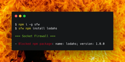
Socket Firewall is a free tool that blocks malicious packages at install time, giving developers proactive protection against rising supply chain attacks.

Research
Socket uncovers malicious Rust crates impersonating fast_log to steal Solana and Ethereum wallet keys from source code.