Product
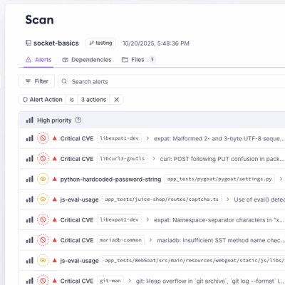
Introducing Webhook Events for Pull Request Scans
Add real-time Socket webhook events to your workflows to automatically receive pull request scan results and security alerts in real time.
A python module for obtaining reduced(min,max,avg) value from netCDF file under a polygon region

A Python3 module for extracting data from netcdf file under a shapefile region.

pyscissor can be installed using the following commands
$ git clone https://github.com/nzahasan/pyscissor.git
$ cd pyscissor
$ python3 setup.py install
or using pip
$ pip install pyscissor
import fiona
import numpy as np
from netCDF4 import Dataset
from shapely.geometry import shape
from pyscissor import scissor


# read shapefile
sf = fiona.open('data/shape.geojson')
shapely_shp =shape(sf.get(0)['geometry'])


# read netcdf
nf = Dataset('data/sample_2.nc','r')
lats = nf.variables['lat'][:]
lons = nf.variables['lon'][:]

# create scissor object
pys = scissor(shapely_shp,lats,lons)

weight_grid = pys.get_masked_weight() #=> returns a masked array containing weights

# get weighted average
avg = np.average(var,weights=weight_grid)

# if only intersection mask with shape is needed use `weight_grid.mask`
A detailed use case can be found in the following jupyter notebooks
this package contains a nc2ts_by_shp.py script. A command line tool that can be used to quickly extract
reduced(min/max/average/weighted average) time-series form netcdf file with shapefile
# with 3d array [data/sample_2.nc] generel case
$ nc2ts_by_shp.py -nc=sample_2.nc -nci='Y=lat;X=lon;T=time;V=tmin;' -s=shape_esri.zip \
		-sp='ADM2_EN;ADM3_EN' -r=avg -o=test2.csv

# with 4d array [data/sample_1.nc]
$ nc2ts_by_shp.py -nc=sample_1.nc -nci='Y=lat;X=lon;T=time;V=temperature;slicer=[:,0,:,:]' -sf=shape_esri.zip \
		-sfp='ADM2_EN;ADM3_EN' -r=wavg -o=test1.csv
Options:
-nc  = netcdf file

-nci = netcdf variable and dimension information
		available options:
		X = x dimension variable name,
		Y = y dimension variable name,
		T = time dimension variable name,
		V = variable name,
		slicer = slicing index for obtaining 3d array [optional]

		note: `slicer` is required if variable has more than three dimension

-sf  = shape file ( can be zipped shapefile, shapefile or geojson )

-sfp = shapefile properties
		only required when shapefile contains multiple records

-r   = reducer, default is average
		Available options: min,max,avg,wavg

-o   = output file name
- when shapefile and netcdf file have different projection
- shapefile dosen't fully reside within netcdf bounds
FAQs
A python module for obtaining reduced(min,max,avg) value from netCDF file under a polygon region
We found that pyscissor demonstrated a healthy version release cadence and project activity because the last version was released less than a year ago. It has 1 open source maintainer collaborating on the project.
Did you know?

Socket for GitHub automatically highlights issues in each pull request and monitors the health of all your open source dependencies. Discover the contents of your packages and block harmful activity before you install or update your dependencies.

Product
Add real-time Socket webhook events to your workflows to automatically receive pull request scan results and security alerts in real time.

Research
The Socket Threat Research Team uncovered malicious NuGet packages typosquatting the popular Nethereum project to steal wallet keys.

Product
A single platform for static analysis, secrets detection, container scanning, and CVE checks—built on trusted open source tools, ready to run out of the box.