Product
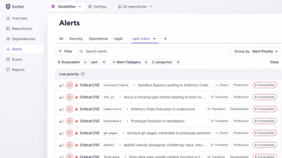
Introducing Custom Tabs for Org Alerts
Create and share saved alert views with custom tabs on the org alerts page, making it easier for teams to return to consistent, named filter sets.
By André Staltz - Jan 20, 2026
aframe-scatterplot
Advanced tools
An all purpose scatterplot data vis component for the AFrame WebVR Framework.
Check out the example application: https://zcanter.github.io/vr-scatterplot/

Install and use by directly including the browser file:
You must also include a link the D3 JavaScript data visualization framework.
<head>
<title>My A-Frame Scene</title>
<script src="https://aframe.io/releases/0.4.0/aframe.min.js"></script>
<script src="https://cdnjs.cloudflare.com/ajax/libs/d3/4.4.1/d3.min.js"></script>
<script src="https://cdn.rawgit.com/zcanter/aframe-scatterplot/master/dist/a-scatterplot.min.js"></script>
</head>
<body>
<a-scene>
<a-scatterplot src="url(example.json)" x="field1" y="field2" z="field3" val="field4"></a-scatterplot>
</a-scene>
</body>
Install via NPM:
npm install aframe
npm install d3
npm install aframe-scatterplot
Then register and use.
require('aframe');
require('d3');
require('aframe-scatterplot');
Datasets should be formatted as follows:
[
 {
   // Data Point
   "Field1": 13.90738679789567,
   "Field2": 11.77935227940546,
   "Field3": 12.02052097080796,
   "Field4": 11.31274091176219,
   "Field5": 14.13415151546462,
 },
 {
   // Data Point
   "Field1": 12.29829187876160,
   "Field2": 10.12398967761787,
   "Field3": 16.81298749861520,
   "Field4": 13.92371645984898,
   "Field5": 11.35138647618786,
 },
 {...},
 {...},
 ]
Example (Sea Surface Temperature 1km resolution):
[
 {
   "lat":-80,
   "lon":-180,
   "val":-108
 },
 {
   "lat":-80,
   "lon":-179,
   "val":-103
 },
 {...},
 {...},
 ]
How can I format my data in this way?
The easiest way to do this is to get a CSV of your dataset and use the online CSV to JSON conversion tool convertcsv. If you are a programmer you can use your favorite language to do so as well. Most popular programming languages have JSON writing capabilities of some sort.
How can I get a CSV export of my data?
The easiest way to get a CSV export is to open your data in Excel or Google Sheets and export as it a CSV file. You can also do this programmatically in your favorite language.
Can I only use geospacial data?
No, you can use non-geospacial data as long as it is formatted in the style shown above. It is important to note though that if two spacial dimensions share a unit of measurement (i.e. x and y dimensions are both in kelvin) you should specify this in the relationship option (detailed in API below).
How many fields can I have?
You may have as many fields as you like, but note you can only visualize three spacial dimensions and one color mapped dimension at any given time.
How many points can my dataset have?
We have experimented with over 5 million data points with no problems.
Do I need to normalize or scale my values?
No, the a-scatterplot component will do that for you programmatically. It is totally fine for you to leave the values at their original readings.
Where can I find example data?
Example datasets can be found here.
| Property | Example | Description | Default Value |
|---|---|---|---|
| src | url(data.json) | The path to the data set | none |
| title | Sea Surface Temperature | Title of the dataset | undefined |
| x | lat | X dimension from field name | undefined |
| y | val | Y dimension from field name | undefined |
| z | lon | Z dimension from field name | undefined |
| val | val | Color mapped dimension from field name | undefined |
| colorpreset | jet | Name of the color map preset | jet |
| fillval | -32768, 4506 | Number (or numbers) representing fill values/ignored values separated by comma | none |
| relationship | xz | Dimensions that share units of measurements | none |
| pointSize | 3.5 | Size of the rendered data point | 1 |
| raw | [{lat: -79, lon: 180, val: 103},...] | The raw data in a JS object array | none |
| xfill | -45, 63 | Fill or ignored values in X dimension | none |
| yfill | -78 | Fill or ignored values in Y dimension | none |
| zfill | 12 | Fill or ignored values in Z dimension | none |
| xLimit | 0.7 | Fill value or desired ignored value in X dimension | 1 |
| yLimit | 0.5 | Fill value or desired ignored value in X dimension | 1 |
| zLimit | 0.2 | Fill value or desired ignored value in X dimension | 1 |
| xFlip | true | Invert the X shape | false |
| yFlip | true | Invert the Y shape | false |
| zFlip | true | Invert the Z shape | false |
Feel free to open a GitHub Issue or to contact me directly at zrcanter [-at-] gmail
FAQs
AFrame JSON data scatterplot component
The npm package aframe-scatterplot receives a total of 2 weekly downloads. As such, aframe-scatterplot popularity was classified as not popular.
We found that aframe-scatterplot demonstrated a not healthy version release cadence and project activity because the last version was released a year ago. It has 1 open source maintainer collaborating on the project.
Did you know?

Socket for GitHub automatically highlights issues in each pull request and monitors the health of all your open source dependencies. Discover the contents of your packages and block harmful activity before you install or update your dependencies.
Product
Create and share saved alert views with custom tabs on the org alerts page, making it easier for teams to return to consistent, named filter sets.
Product
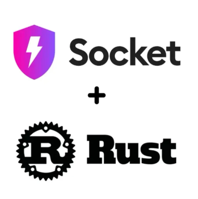
Socket’s Rust and Cargo support is now generally available, providing dependency analysis and supply chain visibility for Rust projects.

Security News
Chrome 144 introduces the Temporal API, a modern approach to date and time handling designed to fix long-standing issues with JavaScript’s Date object.