Product
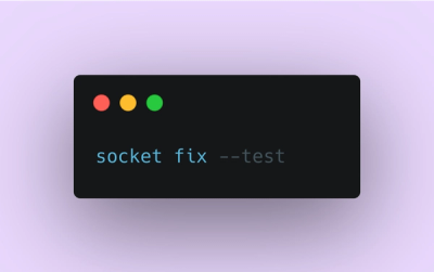
Introducing Socket Fix for Safe, Automated Dependency Upgrades
Automatically fix and test dependency updates with socket fix—a new CLI tool that turns CVE alerts into safe, automated upgrades.
By John-David Dalton - Apr 25, 2025
leaflet-control-geocoder
Advanced tools
Extendable geocoder with builtin support for OpenStreetMap Nominatim, Bing, Google, Mapbox, MapQuest, What3Words, Photon, Pelias, HERE, Neutrino, Plus codes
I need to take some of your time. I can't believe we let shit like the Kathy Sierra incident or what happened to Brianna Wu happen over and over again. I can't believe we, the open source community, let sexist, misogynous shit happen over and over again.
I strongly believe that it is my — and your — duty to make the open source community, as well as the tech community at large, a community where everyone feel welcome and is accepted. At the very minimum, that means making sure the community and its forums both are safe, and are perceived as safe. It means being friendly and inclusive, even when you disagree with people. It means not shrugging off discussions about sexism and inclusiveness with handwaving about censorship and free speech. For a more elaborate document on what that means, the NPM Code of Conduct is a good start, Geek Feminism's resources for allies contains much more.
While I can't force anyone to do anything, if you happen to disagree with this, I ask of you not to use any of the open source I have published. Nor am I interested in contributions from people who can't accept or act respectfully towards other humans regardless of gender identity, sexual orientation, disability, ethnicity, religion, age, physical appearance, body size, race, or similar personal characteristics. If you think feminism, anti-racism or the LGBT movement is somehow wrong, disturbing or irrelevant, I ask you to go elsewhere to find software.

A simple geocoder for Leaflet that by default uses OSM/Nominatim.
The plugin supports many different data providers:
The plugin can easily be extended to support other providers. Current extensions:
Download latest release, or obtain the latest release via unpkg.com:
<link rel="stylesheet" href="https://unpkg.com/leaflet-control-geocoder/dist/Control.Geocoder.css" />
<script src="https://unpkg.com/leaflet-control-geocoder/dist/Control.Geocoder.js"></script>
Add the control to a map instance:
var map = L.map('map').setView([0, 0], 2);
L.tileLayer('https://{s}.tile.osm.org/{z}/{x}/{y}.png', {
attribution: '© <a href="https://osm.org/copyright">OpenStreetMap</a> contributors'
}).addTo(map);
L.Control.geocoder().addTo(map);
By default, when a geocoding result is found, the control will center the map on it and place
a marker at its location. This can be customized by listening to the control's markgeocode
event. To remove the control's default handler for marking a result, set the option
defaultMarkGeocode to false.
For example:
var geocoder = L.Control.geocoder({
  defaultMarkGeocode: false
})
  .on('markgeocode', function(e) {
    var bbox = e.geocode.bbox;
    var poly = L.polygon([
      bbox.getSouthEast(),
      bbox.getNorthEast(),
      bbox.getNorthWest(),
      bbox.getSouthWest()
    ]).addTo(map);
    map.fitBounds(poly.getBounds());
  })
  .addTo(map);
This will add a polygon representing the result's boundingbox when a result is selected.
This is the geocoder control. It works like any other Leaflet control, and is added to the map.
This plugin supports the standard JavaScript constructor (to be invoked using new) as well as the class factory methods known from Leaflet:
new L.Control.Geocoder(options);
// or
L.Control.geocoder(options);
| Option | Type | Default | Description |
|---|---|---|---|
collapsed | Boolean | true | Collapse control unless hovered/clicked |
expand | String | "touch" | How to expand a collapsed control: touch or click or hover |
position | String | "topright" | Control position |
placeholder | String | "Search..." | Placeholder text for text input |
errorMessage | String | "Nothing found." | Message when no result found / geocoding error occurs |
geocoder | IGeocoder | new L.Control.Geocoder.Nominatim() | Object to perform the actual geocoding queries |
showUniqueResult | Boolean | true | Immediately show the unique result without prompting for alternatives |
showResultIcons | Boolean | false | Show icons for geocoding results (if available); supported by Nominatim |
suggestMinLength | Number | 3 | Minimum number characters before suggest functionality is used (if available from geocoder) |
suggestTimeout | Number | 250 | Number of milliseconds after typing stopped before suggest functionality is used (if available from geocoder) |
queryMinLength | Number | 1 | Minimum number of characters in search text before performing a query |
| Method | Returns | Description |
|---|---|---|
markGeocode(<GeocodingResult> result) | this | Marks a geocoding result on the map |
Uses Nominatim to respond to geocoding queries. This is the default
geocoding service used by the control, unless otherwise specified in the options. Implements IGeocoder.
Unless using your own Nominatim installation, please refer to the Nominatim usage policy.
new L.Control.Geocoder.Nominatim(options);
// or
L.Control.Geocoder.nominatim(options);
| Option | Type | Default | Description |
|---|---|---|---|
serviceUrl | String | "https://nominatim.openstreetmap.org/" | URL of the service |
geocodingQueryParams | Object | {} | Additional URL parameters (strings) that will be added to geocoding requests; can be used to restrict results to a specific country for example, by providing the countrycodes parameter to Nominatim |
reverseQueryParams | Object | {} | Additional URL parameters (strings) that will be added to reverse geocoding requests |
htmlTemplate | function | special | A function that takes an GeocodingResult as argument and returns an HTML formatted string that represents the result. Default function breaks up address in parts from most to least specific, in attempt to increase readability compared to Nominatim's naming |
Uses Bing Locations API to respond to geocoding queries. Implements IGeocoder.
Note that you need an API key to use this service.
new L.Control.Geocoder.Bing(<String>key);
// or
L.Control.Geocoder.bing(<String>key);
Uses OpenCage Data API to respond to geocoding queries. Implements IGeocoder.
Note that you need an API key to use this service.
new L.Control.Geocoder.OpenCage(<String>key);
// or
L.Control.Geocoder.opencage(<String>key);
Parses basic latitude/longitude strings such as '50.06773 14.37742', 'N50.06773 W14.37742', 'S 50° 04.064 E 014° 22.645', or 'S 50° 4′ 03.828″, W 14° 22′ 38.712″'.
new L.Control.Geocoder.LatLng(options);
// or
L.Control.Geocoder.latLng(options);
| Option | Type | Default | Description |
|---|---|---|---|
next | IGeocoder | The next geocoder to use for non-supported queries. | |
sizeInMeters | Number | 10000 | The size in meters used for passing to LatLng.toBounds. |
An interface implemented to respond to geocoding queries.
| Method | Returns | Description |
|---|---|---|
geocode(<String> query, callback, context) | GeocodingResult[] | Performs a geocoding query and returns the results to the callback in the provided context |
suggest(<String> query, callback, context) | GeocodingResult[] | Performs a geocoding query suggestion (this happens while typing) and returns the results to the callback in the provided context |
reverse(<L.LatLng> location, <Number> scale, callback, context) | GeocodingResult[] | Performs a reverse geocoding query and returns the results to the callback in the provided context |
An object that represents a result from a geocoding query.
| Property | Type | Description |
|---|---|---|
name | String | Name of found location |
bbox | L.LatLngBounds | The bounds of the location |
center | L.LatLng | The center coordinate of the location |
icon | String | URL for icon representing result; optional |
html | String | (optional) HTML formatted representation of the name |
FAQs
Extendable geocoder with builtin support for OpenStreetMap Nominatim, Bing, Google, Mapbox, MapQuest, What3Words, Photon, Pelias, HERE, Neutrino, Plus codes
The npm package leaflet-control-geocoder receives a total of 16,271 weekly downloads. As such, leaflet-control-geocoder popularity was classified as popular.
We found that leaflet-control-geocoder demonstrated a healthy version release cadence and project activity because the last version was released less than a year ago. It has 0 open source maintainers collaborating on the project.
Did you know?

Socket for GitHub automatically highlights issues in each pull request and monitors the health of all your open source dependencies. Discover the contents of your packages and block harmful activity before you install or update your dependencies.
Product
Automatically fix and test dependency updates with socket fix—a new CLI tool that turns CVE alerts into safe, automated upgrades.

Security News
CISA denies CVE funding issues amid backlash over a new CVE foundation formed by board members, raising concerns about transparency and program governance.
Product
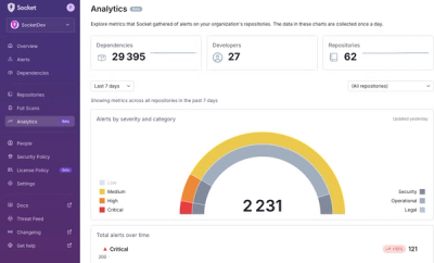
We’re excited to announce a powerful new capability in Socket: historical data and enhanced analytics.