Product
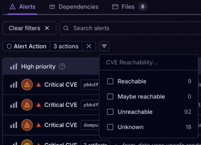
Introducing Tier 1 Reachability: Precision CVE Triage for Enterprise Teams
Socket’s new Tier 1 Reachability filters out up to 80% of irrelevant CVEs, so security teams can focus on the vulnerabilities that matter.
leaflet-rotate-map
Advanced tools
Enable to rotate Leaflet maps. The code is based on a merger between lastest official leaflet version and leaflet rotate branch.
In addition, there are some improvements like:
map.setView_onDragStart when map has maxBounds and map is rotatedLook at index.html file in examples folder
leaflet-src.js in ./dist folder.<script src="leaflet-src.js"></script>
npm install leaflet-rotate-map or yarn add leaflet-rotate-map.To instantiate a L.Map with rotation, add rotate option
const map = L.map('map', { rotate: true });
0.3.1 (2012-02-14)
Control.Layers) for convenient layer switching.map.addLayer(layer, true)) (useful for switching base tile layers).Map zoomstart event (thanks to @Fabiz). #377Map locate method, added ability to watch location continuously and more options. #212inside to Map getBoundsZoom method that allows you to get appropriate zoom for the view to fit inside the given bounds.hasLayer method to Map.Marker zIndexOffset option to be able to set certain markers below/above others. #65urlParams third optional argument to TileLayer constructor for convenience: an object with properties that will be evaluated in the URL template.TileLayer continuousWorld option to disable tile coordinates checking/wrapping.TileLayer tileunload event fired when tile gets removed after panning (by @CodeJosch). #256TileLayer zoomOffset option useful for non-256px tiles (by @msaspence).TileLayer zoomReverse option to reverse zoom numbering (by @Majiir). #406TileLayer.Canvas redraw method (by @mortenbekditlevsen). #459Polyline closestLayerPoint method that's can be useful for interaction features (by @anru). #186setLatLngs method to MultiPolyline and MultiPolygon (by @anru). #194getBounds method to Polyline and Polygon (by @JasonSanford). #253getBounds method to FeatureGroup (by @JasonSanford). #557FeatureGroup setStyle method (also inherited by MultiPolyline and MultiPolygon). #353FeatureGroup invoke method to call a particular method on all layers of the group with the given arguments.ImageOverlay load event. #213minWidth option to Popup (by @marphi). #214LatLng constructor to be more tolerant (and throw descriptive error if latitude or longitude can't be interpreted as a number). #136LatLng distanceTo method (great circle distance) (by @mortenbekditlevsen). #462LatLngBounds toBBoxString method for convenience (by @JasonSanford). #263LatLngBounds intersects(otherBounds) method (thanks to @pagameba). #350LatLngBounds extend method to accept other LatLngBounds in addition to LatLng (by @JasonSanford). #553Bounds intersects(otherBounds) method. #461L.Util.template method for simple string template evaluation.DomUtil.removeClass method (by @anru).Klass.superclass instead of this.superclass (by @anru). #179Map boxzoomstart and boxzoomend events (by @zedd45). #554Popup contentupdate event (by @mehmeta). #548shiftDragZoom map option/property renamed to boxZoom.mouseEventToLatLng method (bringed back in 0.4).Circle was rendered with incorrect radius (didn't take projection exagerration into account). #331Map getBounds would work incorrectly on a date line cross. #295GeoJSON pointToLayer option wouldn't work in a GeometryCollection. #391Circle was rendered with incorrect radius (didn't take projection exaggeration into account). #331Marker setIcon was not working properly (by @marphi). #218 #311Marker setLatLng was not working if it's set before adding the marker to a map. #222Marker setLatLng (by @tjarratt). #272closePopup option (by @jgerigmeyer).Bounds contains method (by @anru). #180Polygon with new L.Polygon() would raise an error.movestart event would fire after zoom animation.setPrefix. #195TileLayer load event wouldn't fire in some edge cases (by @dravnic).movestart didn't fire on panning animation.EPSG:3395 CRS (by @Savvkin). #358setView or panTo to the current center. #231FAQs
Enable to rotate Leaflet map
The npm package leaflet-rotate-map receives a total of 110 weekly downloads. As such, leaflet-rotate-map popularity was classified as not popular.
We found that leaflet-rotate-map demonstrated a not healthy version release cadence and project activity because the last version was released a year ago. It has 1 open source maintainer collaborating on the project.
Did you know?

Socket for GitHub automatically highlights issues in each pull request and monitors the health of all your open source dependencies. Discover the contents of your packages and block harmful activity before you install or update your dependencies.

Product
Socket’s new Tier 1 Reachability filters out up to 80% of irrelevant CVEs, so security teams can focus on the vulnerabilities that matter.

Research
/Security News
Ongoing npm supply chain attack spreads to DuckDB: multiple packages compromised with the same wallet-drainer malware.

Security News
The MCP Steering Committee has launched the official MCP Registry in preview, a central hub for discovering and publishing MCP servers.