Product
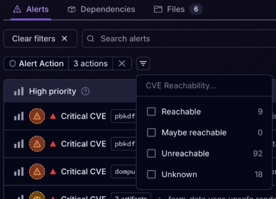
Introducing Tier 1 Reachability: Precision CVE Triage for Enterprise Teams
Socket’s new Tier 1 Reachability filters out up to 80% of irrelevant CVEs, so security teams can focus on the vulnerabilities that matter.
spherical-geometry-js
Advanced tools
This library provides classes and functions for the computation of geometric data on the surface of the Earth. Code ported from the Google Maps Javascript API v3


This library provides classes and functions for the computation of geometric data on the surface of the Earth.
This library ports a small but useful subset of classes from the Google Maps Javascript API version 3, to use as a separate module or in node. I also try to have readable code, so that you can understand what calculations are being made.
import * as geometry from 'spherical-geometry-js';
Or import individual modules
import { computeArea } from 'spherical-geometry-js';
import computeArea from 'spherical-geometry-js/compute-area';
Notes:
LatLngs. See
convertLatLng for more details.The full API of the library is described in the typings file.
Classes and libraries ported from the Google Maps Javascript API:
This module tries to maintain full API compatibility with Google Maps so it can be used as a drop-in replacement.
For convenience, LatLng includes some extra methods.
const latlng = new LatLng(123, 56);
// Alias getters for longitude and latitude

latlng.x === latlng.lng();
latlng.y === latlng.lat();

latlng[0] === latlng.lng();
latlng[1] === latlng.lat();
import { equalLatLngs } from 'spherical-geometry-js';

equalLatLngs(latlng1, latlng2) === latlng1.equals(latlng2);
LatLngimport { LatLng, convertLatLng } from 'spherical-geometry-js';
convertLatLng({ lat: 123, lng: 56 }).equals(new LatLng(123, 56));
convertLatLng([56, 123]).equals(new LatLng(123, 56));
convertLatLng({ x: 56, y: 123 }).equals(new LatLng(123, 56));
Helper function that tries to convert and object into a LatLng. Tries a few
different methods:
If instanceof LatLng, clone the object and return it.
If it has lat and lng properties...
2a. if the properties are functions (like Google LatLngs), use the lat()
and lng() values as latitude and longitude.
2b. otherwise get lat and lng, parse them as floats and use them.
If it has lat and long properties, parse them as floats use them.
If it has lat and lon properties, parse them as floats use them.
If it has latitude and longitude properties, parse them as floats use
them.
If it has number values for 0 and 1 (aka an array of two numbers), use
1 as latitude and 0 as longitude.
If it has x and y properties, try using y as latitude and x and
longitude.
FAQs
This library provides classes and functions for the computation of geometric data on the surface of the Earth. Code ported from the Google Maps Javascript API v3
The npm package spherical-geometry-js receives a total of 11,510 weekly downloads. As such, spherical-geometry-js popularity was classified as popular.
We found that spherical-geometry-js demonstrated a not healthy version release cadence and project activity because the last version was released a year ago. It has 2 open source maintainers collaborating on the project.
Did you know?

Socket for GitHub automatically highlights issues in each pull request and monitors the health of all your open source dependencies. Discover the contents of your packages and block harmful activity before you install or update your dependencies.

Product
Socket’s new Tier 1 Reachability filters out up to 80% of irrelevant CVEs, so security teams can focus on the vulnerabilities that matter.

Research
/Security News
Ongoing npm supply chain attack spreads to DuckDB: multiple packages compromised with the same wallet-drainer malware.

Security News
The MCP Steering Committee has launched the official MCP Registry in preview, a central hub for discovering and publishing MCP servers.