Product
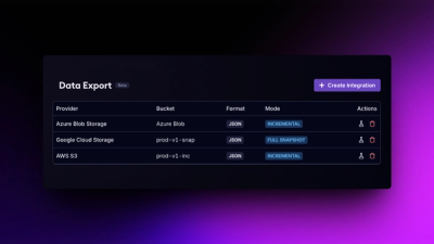
Introducing Data Exports
Export Socket alert data to your own cloud storage in JSON, CSV, or Parquet, with flexible snapshot or incremental delivery.
By Ola Adekola - Apr 23, 2026
geesarfetcher
Advanced tools
Extract Sentinel-1 GRD time-series images over a given area from google earth engine
An easy-to-use Python library to download SAR GRD imagery from Google Earth Engine.
The development of version 0.3.3 added two new functionalities to the library:
Access Google's multi-petabytes of SAR Imagery data from your python code with no dimension restraint. Simply supply coordinates, a time interval and obtain a stack of Sentinel-1 preprocessed PolSAR images. This enables quick data analysis of GRD images to get better insights of the temporal dimension in SAR data without having to bother with essential but potentially time-consuming steps such as coregistration or calibration.
Compatible with python 3.
![]()
The main function of this library is the fetch function:
from geesarfetcher import fetch
from datetime import datetime, timedelta

d = fetch(
      top_left=[-116.17556985040491, 60.527371254744246],
      bottom_right=[-116.1364310564596, 60.54425859382555],
      start_date=datetime(year=2021, month=5, day=20) - timedelta(days=365),
      end_date=datetime(year=2021, month=5, day=20),
      ascending=False,
      scale=10,
      orbit_number="max",
      verbose=2
   ) # returns a dictionnary with access to the data through the 'stack' keyword and to its timestamps through the 'timestamps' keyword
The fetch method loads the full data stack in memory. For large areas or long time interval, using the fetch_and_save alternative, that progressively saves SAR Images as GeoTIFF. They can then be opened in any QGIS-like software as a normal geocoded .tiff file. For more info, see link...
from geesarfetcher import fetch_and_save
from datetime import datetime, timedelta

fetch_and_save(
    save_dir = ".",
    top_left = [-104.77431630331856, 41.729889598264826],
    bottom_right = [-104.65140675742012, 41.81515375846025],
    start_date = datetime(2019, 6, 1),
    end_date = datetime(2019, 6, 3),
    ascending = False,
    scale = 10,
    orbit_number="max",
    n_jobs = 8,
    verbose = 2
)
To fetch over a single point, the process is similar to the difference that we use another function, called fetch_point and only provide a single coordinates tuple rather than either two or 5 tuples for the area query.
from geesarfetcher import fetch_point
from datetime import date, timedelta

d = fetch_point(
    coords = [-104.88572453696113, 41.884778748257574],
    start_date = date.today()-timedelta(days=15),
    end_date = date.today(),
    ascending = False,
    scale = 10,
    orbit_number="max",
    verbose = 2
)
Access to Google Earth Engine is conditioned by the obtention of a GEE account. Once created, you can install the geesarfetcher API and register an identifying token for your Python working environment using the following commands:
pip install geesarfetcher
earthengine authenticate
Pull requests are welcome. For major changes, please open an issue first to discuss what you would like to change. Please make sure to update tests as appropriate.
FAQs
Extract Sentinel-1 GRD time-series images over a given area from google earth engine
We found that geesarfetcher demonstrated a healthy version release cadence and project activity because the last version was released less than a year ago. It has 1 open source maintainer collaborating on the project.
Did you know?

Socket for GitHub automatically highlights issues in each pull request and monitors the health of all your open source dependencies. Discover the contents of your packages and block harmful activity before you install or update your dependencies.
Product
Export Socket alert data to your own cloud storage in JSON, CSV, or Parquet, with flexible snapshot or incremental delivery.
Research
/Security News
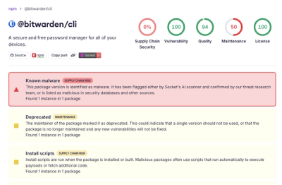
Bitwarden CLI 2026.4.0 was compromised in the Checkmarx supply chain campaign after attackers abused a GitHub Action in Bitwarden’s CI/CD pipeline.

Research
/Security News
Docker and Socket have uncovered malicious Checkmarx KICS images and suspicious code extension releases in a broader supply chain compromise.