 georeader
georeader is a package to process raster data from different satellite missions. georeader makes easy to read specific areas of your image, to reproject images from different satellites to a common grid (georeader.read), to go from vector to raster formats (georeader.vectorize and georeader.rasterize) or to do radiance to reflectance conversions (georeader.reflectance).
georeader is mainly used to process satellite data for scientific usage, to create ML-ready datasets and to implement end-to-end operational inference pipelines (e.g. the Kherson Dam Break floodmap).
Install
The core package dependencies are numpy, rasterio, shapely and geopandas.
pip install georeader-spaceml
Getting started
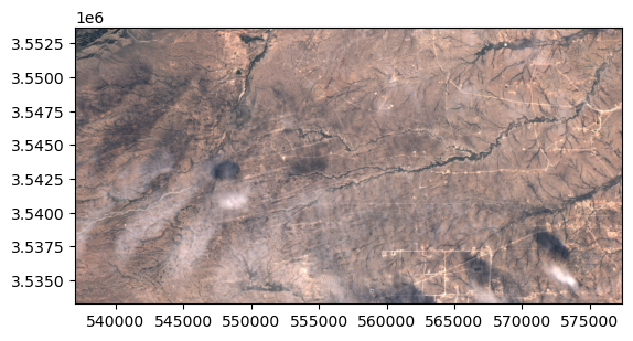
Read from a Sentinel-2 image a fixed size subimage on an specific lon,lat location (directly from the S2 public Google Cloud bucket):
import os
os.environ["GS_NO_SIGN_REQUEST"] = "YES"
from georeader.readers import S2_SAFE_reader
from georeader import read
cords_read = (-104.394, 32.026)
crs_cords = "EPSG:4326"
s2_safe_path = S2_SAFE_reader.s2_public_bucket_path("S2B_MSIL1C_20191008T173219_N0208_R055_T13SER_20191008T204555.SAFE")
s2obj = S2_SAFE_reader.s2loader(s2_safe_path,
out_res=10, bands=["B04","B03","B02"])
s2obj = s2obj.cache_product_to_local_dir(".")
data = read.read_from_center_coords(s2obj,cords_read, shape=(2040, 4040),
crs_center_coords=crs_cords)
data_memory = data.load()
data_memory
>>  Transform: | 10.00, 0.00, 537020.00|
| 0.00,-10.00, 3553680.00|
| 0.00, 0.00, 1.00|
         Shape: (3, 2040, 4040)
         Resolution: (10.0, 10.0)
         Bounds: (537020.0, 3533280.0, 577420.0, 3553680.0)
         CRS: EPSG:32613
         fill_value_default: 0
In the .values attribute we have the plain numpy array that we can plot with show:
from rasterio.plot import show
show(data_memory.values/3500, transform=data_memory.transform)
Saving the GeoTensor as a COG GeoTIFF:
from georeader.save import save_cog
save_cog(data_memory, "s2_crop.tif", descriptions=s2obj.bands)
Tutorials
Sentinel-2
Read rasters from different satellites
Used in other projects
Citation
If you find this code useful please cite:
@article{portales-julia_global_2023,
	title = {Global flood extent segmentation in optical satellite images},
	volume = {13},
	issn = {2045-2322},
	doi = {10.1038/s41598-023-47595-7},
	number = {1},
	urldate = {2023-11-30},
	journal = {Scientific Reports},
	author = {Portalés-Julià, Enrique and Mateo-García, Gonzalo and Purcell, Cormac and Gómez-Chova, Luis},
	month = nov,
	year = {2023},
	pages = {20316},
}
@article{ruzicka_starcop_2023,
	title = {Semantic segmentation of methane plumes with hyperspectral machine learning models},
	volume = {13},
	issn = {2045-2322},
	url = {https://www.nature.com/articles/s41598-023-44918-6},
	doi = {10.1038/s41598-023-44918-6},
	number = {1},
	journal = {Scientific Reports},
	author = {Růžička, Vít and Mateo-Garcia, Gonzalo and Gómez-Chova, Luis and Vaughan, Anna, and Guanter, Luis and Markham, Andrew},
	month = nov,
	year = {2023},
	pages = {19999},
}
Acknowledgments
This research has been supported by the DEEPCLOUD project (PID2019-109026RB-I00) funded by the Spanish Ministry of Science and Innovation (MCIN/AEI/10.13039/501100011033) and the European Union (NextGenerationEU).
 funded by MCIN/AEI/10.13039/501100011033.")