Product
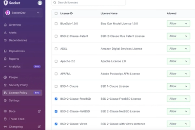
Introducing License Enforcement in Socket
Ensure open-source compliance with Socket’s License Enforcement Beta. Set up your License Policy and secure your software!
By Philipp Burckhardt - Oct 17, 2024
osm-static-maps
Advanced tools
Openstreetmap static maps is a nodejs lib, CLI and server open source inspired on google static map service
Here you have a demo. Also a dynamic version of the demo, for testing purposes.
sudo npm i -g osm-static-maps
osmsm --help
osmsm -g '{"type":"Point","coordinates":[-105.01621,39.57422]}' > map.png
Error: EACCES: permission denied, mkdir '/usr/local/lib/node_modules/osm-static-maps/node_modules/puppeteer/.local-chromium', it's caused by this pupeteer issue https://github.com/puppeteer/puppeteer/issues/367, you can workaround by installing globally with the unsafe-perm flag:sudo npm i -g osm-static-maps --unsafe-perm=true
npm install osm-static-maps
// index.js old school
osmsm = require('osm-static-maps');
osmsm({geojson: geojson})
  .then(function(imageBinaryBuffer) { ... })
  .catch(function(error) { ... })

// index.js modern style (also supports typescript)
import osmsm from 'osm-static-maps'
const imageBinaryBuffer = await osmsm({geojson})
sudo npm i -g osm-static-maps
osmsm serve
Or you can use docker-compose
git clone git@github.com:jperelli/osm-static-maps.git
cd osm-static-maps
docker-compose up
You can use the heroku-hosted alternative directly here
We are currently in the cloud beta, contact me directly at jperelli+osmsm@gmail.com so I can give you access to the cloud service.
All parameters have a short and long version. The short version can be used only with the shell CLI. The long version can be used with the library and can be passed to the app server as GET query params, or POST json body (remember to set the header Content-Type: application/json)
| Parameter | Description | Default Value | |
|---|---|---|---|
| g | geojson | geojson object to be rendered in the map | undefined |
| f | geojsonfile | filename or url to read geojson data from (use '-' to read from stdin on CLI) | undefined |
| H | height | height in pixels of the returned img | 600 |
| W | width | height in pixels of the returned img | 800 |
| c | center | center of the map lon,lat floats string | (center of the geojson) or '-57.9524339,-34.921779' |
| z | zoom | zoomlevel of the leaflet map | if vectorserverUrl available, use 12 else 20 |
| Z | maxZoom | max zoomlevel of the leaflet map | 17 |
| A | attribution | attribution legend | 'osm-static-maps / © OpenStreetMap contributors' |
| t | tileserverUrl | url of a tileserver | 'http://{s}.tile.openstreetmap.org/{z}/{x}/{y}.png' |
| m | vectorserverUrl | url of a vector tile server (MVT style.json) | undefined |
| M | vectorserverToken | token of the vector tile server (MVT) | 'no-token' |
| D | renderToHtml | returns html of the webpage containing the map (instead of a binary image) | false |
| F | type | format of the image returned ('jpeg'/'png') | 'png' |
| q | quality | quality of the image returned (0-100, only for jpg) | 100 |
| x | imagemin | enable lossless compression with optipng / jpegtran | false |
| X | oxipng | enable losslsess compression with oxipng | false |
| a | arrows | render arrows to show the direction of linestrings | false |
| s | scale | enable render a scale ruler (boolean or a json options object) | false |
| T | timeout | miliseconds until page load throws timeout | 20000 |
| k | markerIconOptions | set marker icon options (a json options object) *see note | undefined (leaflet's default marker) |
| S | style | style to apply to each feature (a json options object) *see note | undefined (leaflet's default) |
| e | haltOnConsoleError | throw error if there is any console.error(...) when rendering the map image | false |
Note on markerIconOptions: it's also accepted a markerIconOptions attribute in the geojson feature, for example {"type":"Point","coordinates":[-105.01621,39.57422],"markerIconOptions":{"iconUrl":"https://leafletjs.com/examples/custom-icons/leaf-red.png"}}
Note on style: it's also accepted a pathOptions attribute in the geojson feature, for example {"type":"Polygon","coordinates":[[[-56.698,-36.413],[-56.716,-36.348],[-56.739,-36.311]]],"pathOptions":{"color":"#FF5555"}} (also remember that the # char needs to be passed as %23 if you are using GET params)
Read the blogpost on the creation of this library and how it works internally
Specially to the contributors of
FAQs
Create a static image of a map with the features you want
We found that osm-static-maps demonstrated a healthy version release cadence and project activity because the last version was released less than a year ago. It has 0 open source maintainers collaborating on the project.
Did you know?

Socket for GitHub automatically highlights issues in each pull request and monitors the health of all your open source dependencies. Discover the contents of your packages and block harmful activity before you install or update your dependencies.
Product
Ensure open-source compliance with Socket’s License Enforcement Beta. Set up your License Policy and secure your software!
Product
We're launching a new set of license analysis and compliance features for analyzing, managing, and complying with licenses across a range of supported languages and ecosystems.

Product
We're excited to introduce Socket Optimize, a powerful CLI command to secure open source dependencies with tested, optimized package overrides.