
Research
Security News
Malicious npm Package Targets Solana Developers and Hijacks Funds
A malicious npm package targets Solana developers, rerouting funds in 2% of transactions to a hardcoded address.
apple-maps-server-sdk
Advanced tools
The Apple Maps Server SDK is an npm package that allows easy access to the Apple Maps Server API in JavaScript and TypeScript projects. It includes features such as geocoding, estimated time of arrival, and location search and is well-documented with js/ts examples, making it simpler for developers to access the functionality provided by the API without the need for a deep-dive into Apple's documentation.
Install apple-maps-server-sdk using npm
npm install apple-maps-server-sdk
Install apple-maps-server-sdk using yarn
yarn add apple-maps-server-sdk
import AppleMaps from 'apple-maps-server-sdk'

const appleMaps = new AppleMaps({
    authorizationToken: "AUTHORIZATION TOKEN"
})

// Call the geocode function
appleMaps.geocode({
    q: '1600 Pennsylvania Avenue NW NW, Washington, D.C., 20500,'
})
.then((response) => {
    console.log(response)
})
.catch((err) => {
    console.log(err)
})
{
  "results": [
    {
      "coordinate": {
        "latitude": 38.8976635,
        "longitude": -77.036574
      },
      "displayMapRegion": {
        "southLatitude": 38.8931719235794,
        "westLongitude": -77.04234524082925,
        "northLatitude": 38.9021550764206,
        "eastLongitude": -77.03080275917075
      },
      "name": "1600 Pennsylvania Ave NW",
      "formattedAddressLines": [
        "1600 Pennsylvania Ave NW",
        "Washington, DC  20500",
        "United States"
      ],
      "structuredAddress": {
        "administrativeArea": "District of Columbia",
        "administrativeAreaCode": "DC",
        "locality": "Washington",
        "postCode": "20500",
        "subLocality": "Washington Mall",
        "thoroughfare": "Pennsylvania Ave NW",
        "subThoroughfare": "1600",
        "fullThoroughfare": "1600 Pennsylvania Ave NW",
        "areasOfInterest": [
          "The White House",
          "President's Park"
        ],
        "dependentLocalities": [
          "Washington Mall"
        ]
      },
      "country": "United States",
      "countryCode": "US"
    }
  ]
}
const AppleMaps = require("apple-maps-server-sdk").default

const appleMaps = new AppleMaps({
    authorizationToken: "AUTHORIZATION TOKEN"
})

// Call the geocode function
appleMaps.geocode({
    q: '1600 Pennsylvania Avenue NW NW, Washington, D.C., 20500,'
})
.then((response) => {
    console.log(response)
})
.catch((err) => {
    console.log(err)
})
{
  "results": [
    {
      "coordinate": {
        "latitude": 38.8976635,
        "longitude": -77.036574
      },
      "displayMapRegion": {
        "southLatitude": 38.8931719235794,
        "westLongitude": -77.04234524082925,
        "northLatitude": 38.9021550764206,
        "eastLongitude": -77.03080275917075
      },
      "name": "1600 Pennsylvania Ave NW",
      "formattedAddressLines": [
        "1600 Pennsylvania Ave NW",
        "Washington, DC  20500",
        "United States"
      ],
      "structuredAddress": {
        "administrativeArea": "District of Columbia",
        "administrativeAreaCode": "DC",
        "locality": "Washington",
        "postCode": "20500",
        "subLocality": "Washington Mall",
        "thoroughfare": "Pennsylvania Ave NW",
        "subThoroughfare": "1600",
        "fullThoroughfare": "1600 Pennsylvania Ave NW",
        "areasOfInterest": [
          "The White House",
          "President's Park"
        ],
        "dependentLocalities": [
          "Washington Mall"
        ]
      },
      "country": "United States",
      "countryCode": "US"
    }
  ]
}
Before using this API, you must have an Apple Developer account. Once you have a developer account, follow the steps below to enable the Apple Mapbox API, and generate your Authorization Token.
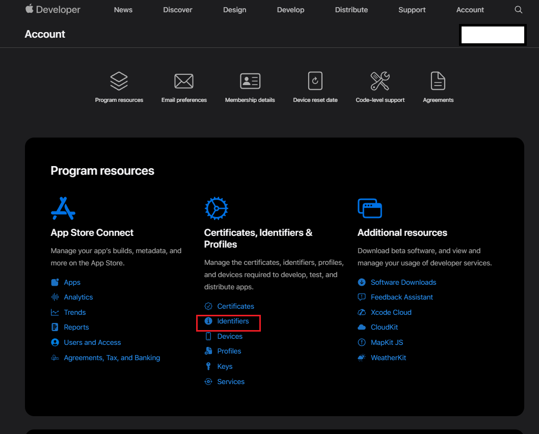
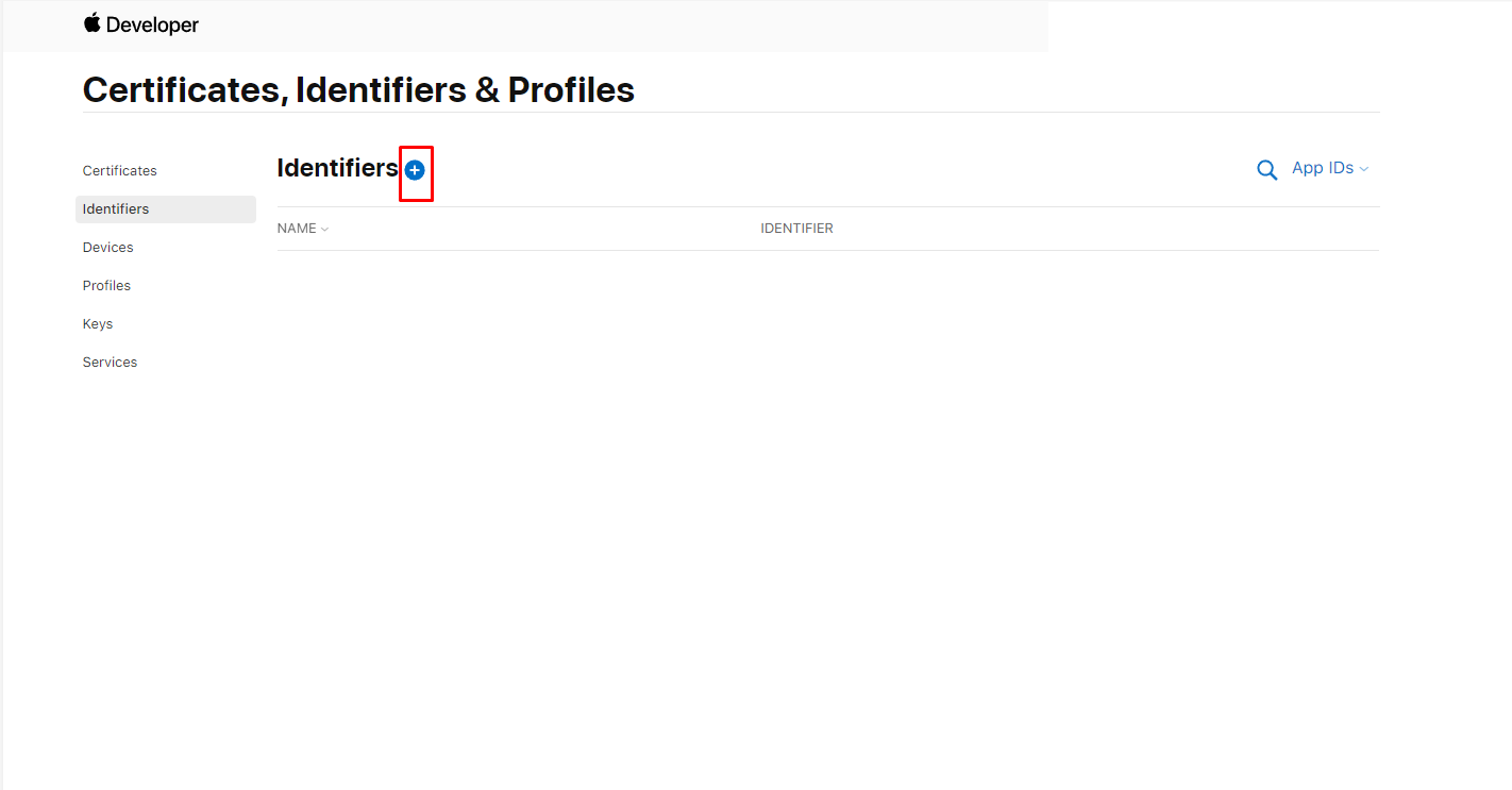
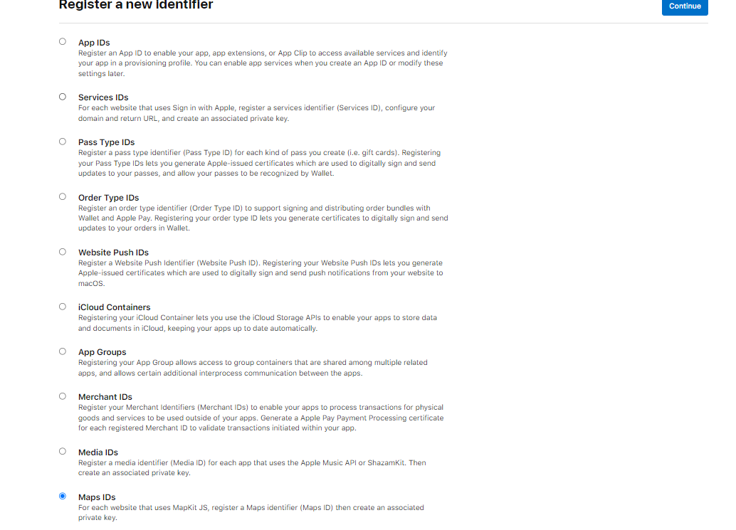
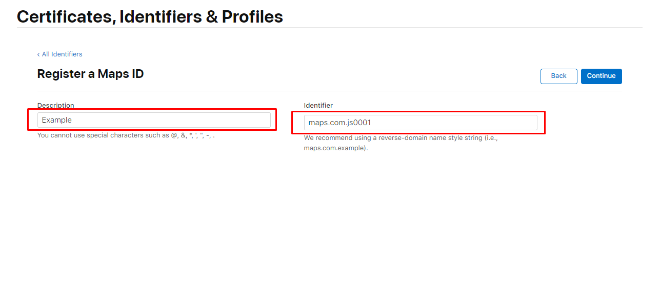

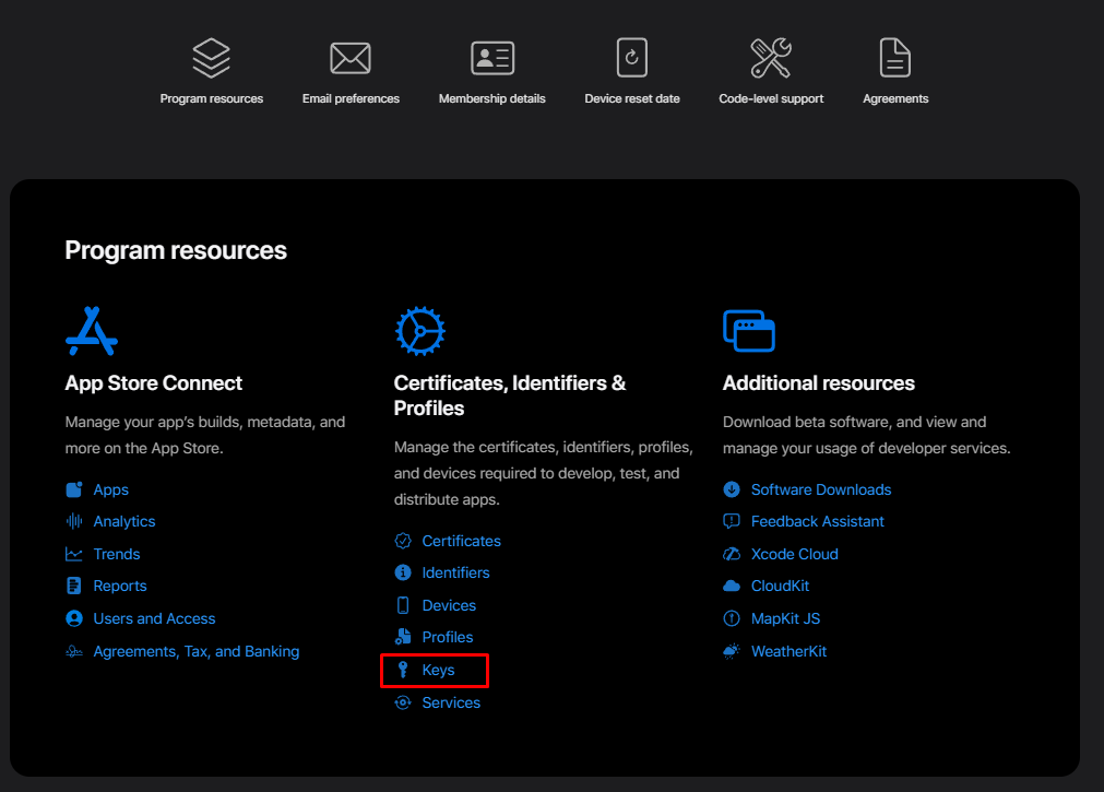
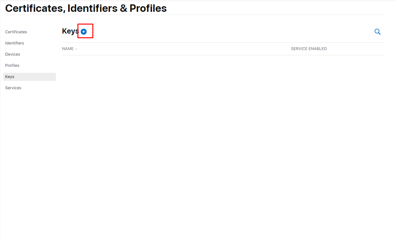
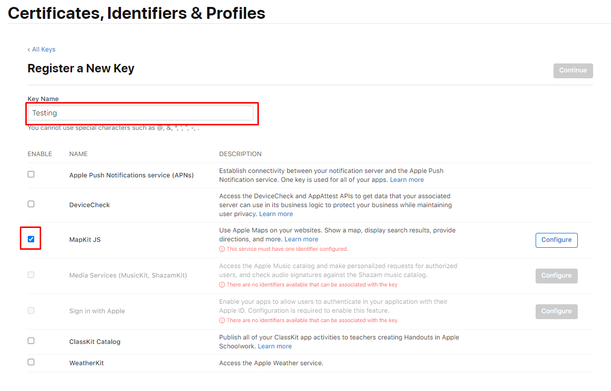
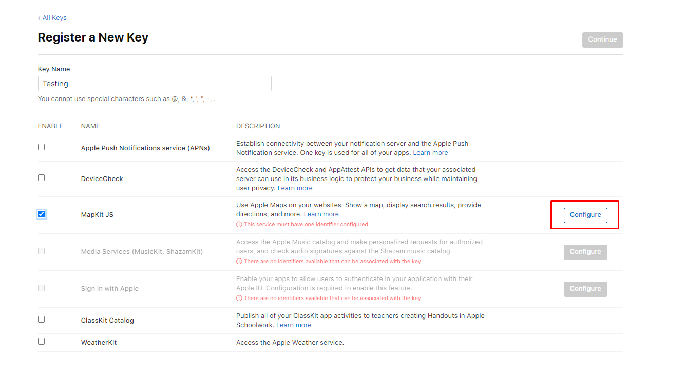
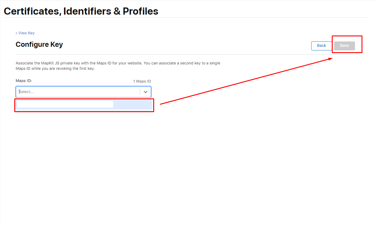
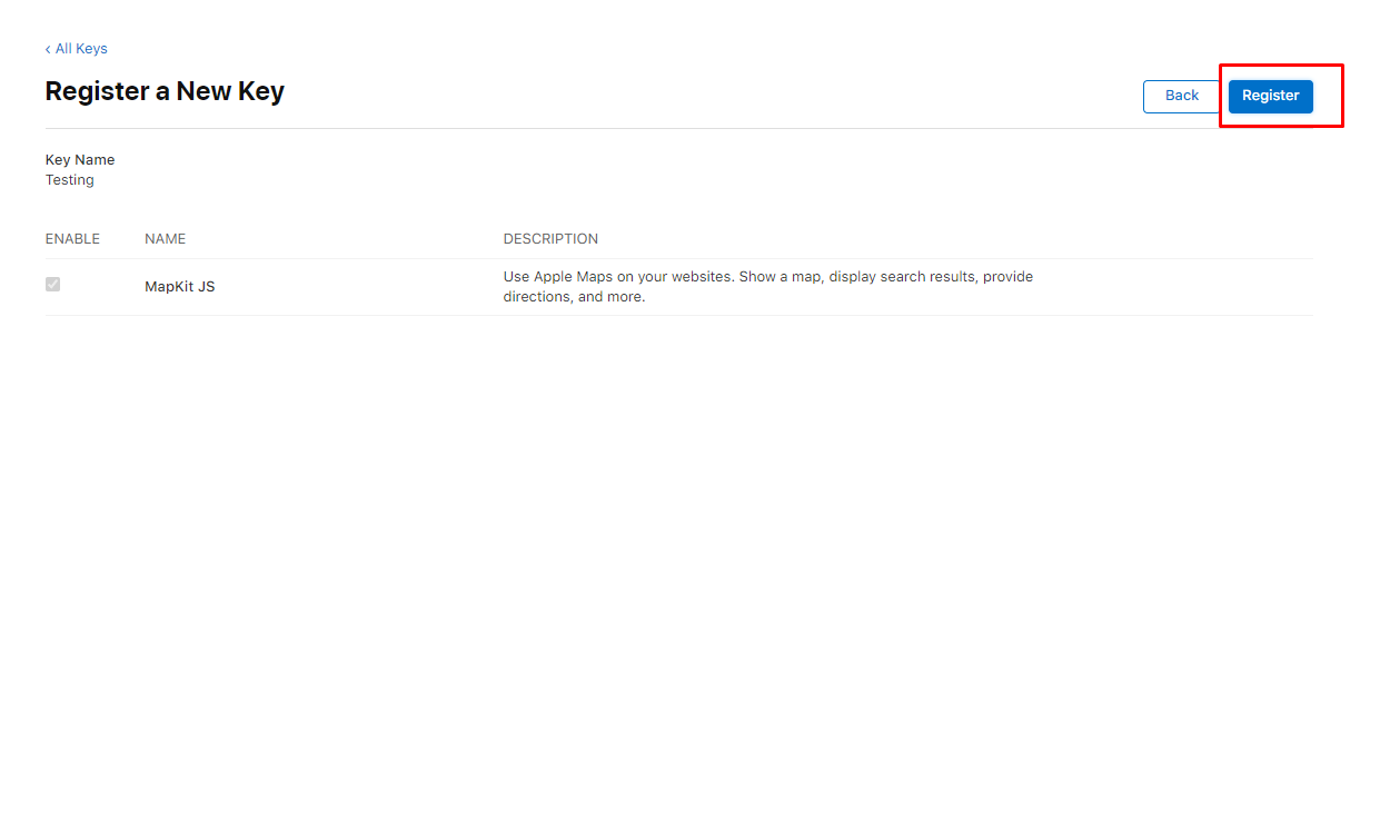
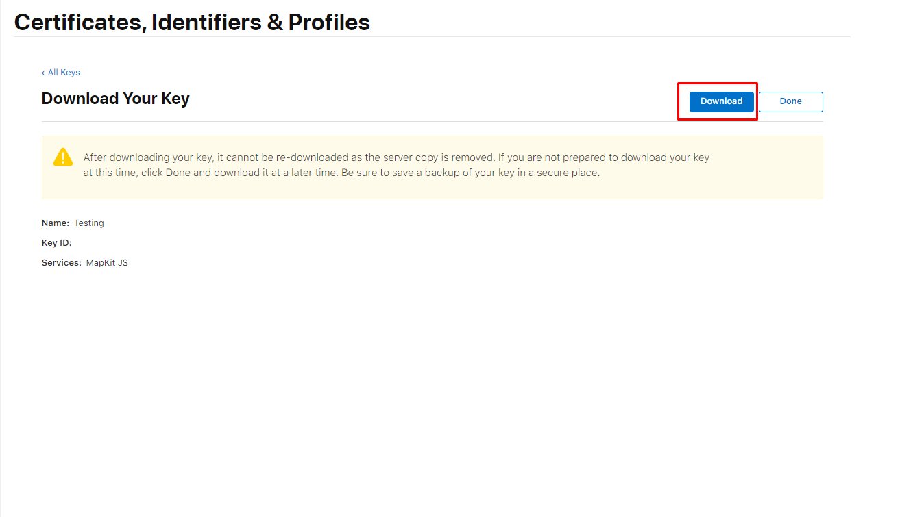
MapKit JS Private Key FileMembership Details and copy your Team ID into the Apple Developer Team ID Field.
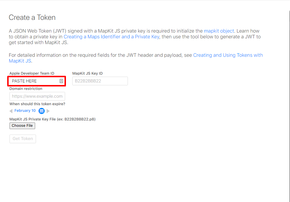


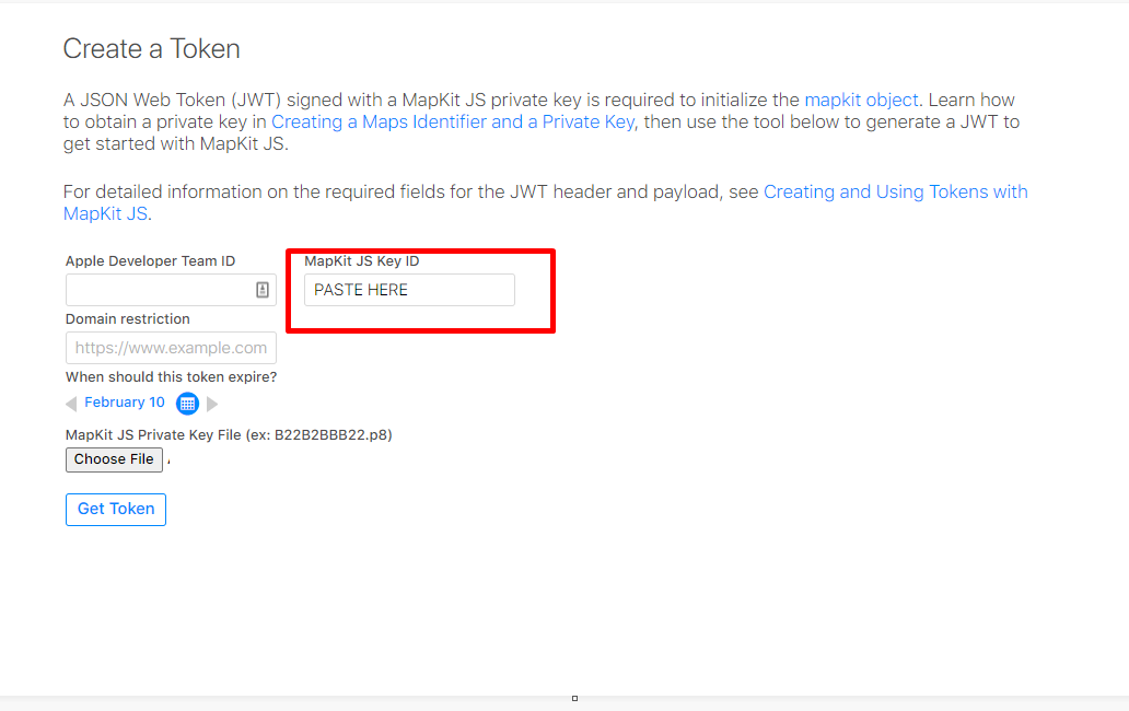
authorizationToken that you will pass when creating an instance of the class. Congratulations, you're ready to go!Fetch geocoded data about an address.
options: supports keys
q [required] - The address to geocode. IE: 1 Apple Park, Cupertino, CAlimitToCountries [optional] - A comma-separated list of country codes to limit the results to IE: US,CA.lang [optional] - The language the server should use when returning the response, specified using a BCP 47 language code. IE: en-US.searchLocation [optional] - A location defined as a hint. Specify the location as a comma-separated string containing the latitude and longitude. IE: 37.78,-122.42.searchRegion [optional] - A region defined as a hint. Specify the region specified as a comma-separated string that describes the region in the form north-latitude, east-longitude, south-latitude, west-longitude. IE: 38,-122.1,37.5,-122.5.userLocation [optional] - The location of the user, specified as a comma-separated string that contains the latitude and longitude. IE: 37.78,-122.42.response
{
  "results": [
    {
      country: string;
      countryCode: string;
      displayMapRegion: {
        eastLongitude: number;
        northLatitude: number;
        southLatitude: number;
        westLongitude: number;
      };
      formattedAddressLines: string[];
      name: string;
      coordinate: {
        latitude: number;
        longitude: number;
      };
      structuredAddress: {
        administrativeArea: string;
        administrativeAreaCode: string;
        areasOfInterest: string[];
        dependentLocalities: string[];
        fullThoroughfare: string;
        locality: string;
        postCode: string;
        subLocality: string;
        subThoroughfare: string;
        thoroughfare: string;
      }
    }
  ]
}
Fetch reverse geocoded data about coordinates.
options: supports keys
loc [required] - The coordinate to reverse geocode as a comma-separated string that contains the latitude and longitude. IE: 37.3316851,-122.0300674.lang [optional] - The language the server should use when returning the response, specified using a BCP 47 language code. IE: en-US.response
{
  "results": [
    {
      country: string;
      countryCode: string;
      displayMapRegion: {
        eastLongitude: number;
        northLatitude: number;
        southLatitude: number;
        westLongitude: number;
      };
      formattedAddressLines: string[];
      name: string;
      coordinate: {
        latitude: number;
        longitude: number;
      };
      structuredAddress: {
        administrativeArea: string;
        administrativeAreaCode: string;
        areasOfInterest: string[];
        dependentLocalities: string[];
        fullThoroughfare: string;
        locality: string;
        postCode: string;
        subLocality: string;
        subThoroughfare: string;
        thoroughfare: string;
      }
    }
  ]
}
Returns the estimated time of arrival (ETA) and distance between starting and ending locations.
options: supports keys
origin [required] - The starting point for estimated arrival time requests, specified as a comma-separated string that contains the latitude and longitude. IE: 37.331423,-122.030503.destinations [required] - Destination coordinates represented as pairs of latitude and longitude separated by a vertical bar character (”|”).
IE: 37.32556561130194,-121.94635203581443|37.44176585512703,-122.17259315798667.The parameter must specify at least one destination coordinate, but no more than 10 destinations. Specify the location as a comma-separated string that contains the latitude and longitude.
transportType [optional] - The mode of transportation to use when estimating arrival times.Default: Automobile
Possible values: Automobile, Transit, Walking
departureDate [optional] - The time of departure to use in an estimated arrival time request, in ISO 8601 format in UTC time.
IE: 2020-09-15T16:42:00Z.If you don’t specify a departure date, the server uses the current date and time when you make the request.
arrivalDate [optional] - The intended time of arrival in ISO 8601 format in UTC time.response
{
  "etas": [
    {
      destination: {
        latitude: number;
        longitude: number;
      };
      distanceMeters: number;
      expectedTravelTimeSeconds: number;
      staticTravelTimeSeconds: number;
      transportType: "Automobile" | "Transit" | "Walking";
    }
  ]
}
Find places by name or by specific search criteria.
options: supports keys
q [required] - The place to search for. IE: eiffel tower.excludePoiCategories [optional] - A comma-separated list of strings that describes the points of interest to exclude from the search results. IE: Restaurant,Cafe. See https://developer.apple.com/documentation/applemapsserverapi/poicategory for a list of all possible PoiCategories.includePoiCategories [optional] - A comma-separated list of strings that describes the points of interest to include in the search results. IE: Restaurant,Cafe. See https://developer.apple.com/documentation/applemapsserverapi/poicategory for a list of all possible PoiCategories.limitToCountries [optional] - A comma-separated list of ISO ALPHA-2 codes of the countries to limit the results to. IE: US,CA limits the search to the United States and Canada.resultTypeFilter [optional] - A comma-separated list of strings that describes the kind of result types to include in the response. IE: Poi.Possible values: Poi, Address
lang [optional] - The language the server should use when returning the response. IE: en-US. Defaults to en-US.searchLocation [optional] - A location defined as a hint. Specify the location as a comma-separated string containing the latitude and longitude. IE: 37.78,-122.42.searchRegion [optional] - A region defined as a hint. Specify the region specified as a comma-separated string that describes the region in the form north-latitude,east-longitude,south-latitude,west-longitude. IE: 38,-122.1,37.5,-122.5.userLocation [optional] - The location of the user, specified as a comma-separated string that contains the latitude and longitude. IE: 37.78,-122.42.response
{
  "displayMapRegion": {
    eastLongitude: number;
    northLatitude: number;
    southLatitude: number;
    westLongitude: number;
  }
  "results": [
    {
      poiCategory: PoiCategory;
      country: string;
      countryCode: string;
      displayMapRegion: {
        eastLongitude: number;
        northLatitude: number;
        southLatitude: number;
        westLongitude: number;
      };
      formattedAddressLines: string[];
      name: string;
      coordinate: {
        latitude: number;
        longitude: number;
      };
      structuredAddress: {
        administrativeArea: string;
        administrativeAreaCode: string;
        areasOfInterest: string[];
        dependentLocalities: string[];
        fullThoroughfare: string;
        locality: string;
        postCode: string;
        subLocality: string;
        subThoroughfare: string;
        thoroughfare: string;
      }
    }
  ]
}
FAQs
An SDK for the Apple Maps Server API
We found that apple-maps-server-sdk demonstrated a not healthy version release cadence and project activity because the last version was released a year ago. It has 1 open source maintainer collaborating on the project.
Did you know?

Socket for GitHub automatically highlights issues in each pull request and monitors the health of all your open source dependencies. Discover the contents of your packages and block harmful activity before you install or update your dependencies.

Research
Security News
A malicious npm package targets Solana developers, rerouting funds in 2% of transactions to a hardcoded address.

Security News
Research
Socket researchers have discovered malicious npm packages targeting crypto developers, stealing credentials and wallet data using spyware delivered through typosquats of popular cryptographic libraries.
Security News
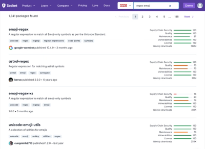
Socket's package search now displays weekly downloads for npm packages, helping developers quickly assess popularity and make more informed decisions.