Security News
Node.js EOL Versions CVE Dubbed the "Worst CVE of the Year" by Security Experts
Critics call the Node.js EOL CVE a misuse of the system, sparking debate over CVE standards and the growing noise in vulnerability databases.

一款高德地图weex插件,当前版本支持定位,缩放,显示信息窗体等地图常用操作。
编辑你的weex文件
<template>
<div class="container">
<weex-amap class="map" id="map2017" scale="true" geolocation="true" center="{{pos}}" >
<weex-amap-marker position="{{point.position}}" title="{{point.title}}"></weex-amap-marker>
</weex-amap>
</div>
</template>
<style>
.container{
position: relative;
flex:1;
background-color: #fff;
}
.map{
flex: 1;
position: relative;
background-color: #fff;
min-height: 600;
}
</style>
<script>
module.exports = {
data: {
pos:[116.487, 40.00003],
point: {
position: [112,36],
title: 'this is a marker'
}
},
}
</script>
| 属性 | 类型 | Demo | 描述 |
|---|---|---|---|
| center | array | [116.487, 40.00003] | 传入地理位置坐标[x,y] 默认为当前定位位置 |
| zoom | number | 11 | 缩放级别 |
| zoomEnable | boolean | true | 是否允许缩放 |
| marker | array | [{position:[116,12]}] | 点标记物的属性 |
| geolocation | boolean | true | 添加定位控件 |
| sdkKey | object | {ios:'xxx',android: 'xxx',h5: 'xxx'} | 指定开发者的 SDK 密匙 |
建议你前往高德开发者社区申请你对应产品的Key,保证地图正常工作
| 事件 | 描述 |
|---|---|
| zoomchange | 用户缩放改变 |
| dragend | 用户拖拽完成 |
| 属性 | 类型 | Demo | 描述 |
|---|---|---|---|
| position | array | [116.487, 40.00003] | 传入地理位置坐标[x,y] 默认为当前定位位置 |
| icon | string | some_icon_url | 图标的url地址 |
| title | string | 'this is a marker' | 坐标点的名称 |
| 事件 | 描述 |
|---|---|
| click | 用户点击标记物 |
在地图上绘制折线
| 属性 | 类型 | Demo | 描述 |
|---|---|---|---|
| path | array | [[116.487, 40.00003],[113.487, 40.0002]...] | 折线的节点坐标数组 |
| stroke-color | string | #000 | 线条颜色 |
| stroke-width | number | 2 | 线条宽度 |
| stroke-opacity | number | 0.5 | 线条透明度[0-1] |
| stroke-style | string | solid | 线条的样式 实线:solid,虚线:dashed |
code example:
<weex-amap-polyline path="path" stroke-color="#000" stroke-weight="2"></weex-amap-polyline>

<script>
module.exports = {
  data: {
    path: [
      [116.368904, 39.913423],
      [116.382122, 39.901176],
      [116.387271, 39.912501],
      [116.398258, 39.904600]
    ],

  }
}
</script>
在地图上绘制多边形
| 属性 | 类型 | Demo | 描述 |
|---|---|---|---|
| path | array | [[116.487, 40.00003],[113.487, 40.0002]...] | 多边形轮廓线的节点坐标数组 |
| fill-color | string | #000 | 多边形填充颜色 |
| fill-opacity | string | #000 | 多边形填充透明度 |
| stroke-color | string | #000 | 线条颜色 |
| stroke-width | number | 2 | 线条宽度 |
| stroke-opacity | number | 0.5 | 线条透明度[0-1] |
| stroke-style | string | solid | 线条的样式 实线:solid,虚线:dashed |
在地图上绘制圆形
| 属性 | 类型 | Demo | 描述 |
|---|---|---|---|
| center | array | [116.346, 40.234234] | 圆形位置 |
| radius | number | 50 | 圆的半径 |
| fill-color | string | #000 | 圆的填充颜色 |
| fill-opacity | string | #000 | 圆的填充透明度 |
| stroke-color | string | #000 | 圆的轮廓线条颜色 |
| stroke-width | number | 2 | 圆的轮廓线条宽度 |
| stroke-opacity | number | 0.5 | 圆的轮廓线条透明度[0-1] |
| stroke-style | string | solid | 圆的轮廓线条的样式 实线:solid,虚线:dashed |
在地图上显示自定义窗体
| 属性 | 类型 | Demo | 描述 |
|---|---|---|---|
| position | array | [[116.487, 40.00003] | 在地图上的位置 |
| open | boolean | true | 是否在地图上打开 |
| offset | array | 偏移 | 相对定位点坐标偏移 |
| children | weex comonnet | This is a info window | 窗体的内容 |
SDK限制,一个地图只允许显示一个infoWindow
它支持下面的方法:
获取用户的位置信息
{
  data:{
    position: []
  },
  result: 'success'
}
计算两个标记点的距离
该方法接收三个参数 进行计算比如:
@param coor1 坐标1
@param coor2 坐标2
@param callback 计算完成后的回调 会返回一个计算出的具体距离,单位 米
//...
amap.getLineDistance(this.marker1.position, this.marker2.position, (res) => {
  if (res.result == 'success') {
    this.distance = '两点相距' + res.data + '米';
    console.log(res.data.distance + '米');
  } else {
    console.log('计算失败');
  }
})
判断几何形是否包含某个点
该方法接收两个参数,返回一个boolean值
@param coor 点的坐标
@param polygonRef 多边形的ref
@param callbcak 计算完成后的回调 会返回一个运算的结果,其中data字段是个boolean,表示是否包含
amap.polygonContainsMarker([114.23423, 43.2222], this.$ref('polygon2017'), (res) => {
  if (res.result == 'success') {
    console.log(res.data ? '存在' : '不存在' );
  }
})
<template>
  <weex-amap class="map" id="map2017" center="{{pos}}" ></weex-amap>
  <div class="btn-wrap">
    <div onclick="setUserLocation" class="btnbox"><text class="btn" >set location </text></div>
    <text class="tips">进行当前定位</text>
  </div>
</template>

<script>
  const Amap = require('@weex-module/amap');
  module.exports = {
    data: {
      pos:[116.487, 40.00003]
    },

    methods: {
      setUserLocation() {
        const self = this;
        Amap.getUserLocation(this.$el('map2017').ref, function (data) {
          if(data.result == 'success') {
            self.pos = data.data.position;
          }
        });
    }
  };

</script>
直接点击Demo可以演示当前版本支持的功能
参考weexpack命令(网址)来测试地图组件demo:
1.安装weexpack
npm install -g weexpack
2.创建工程,如MyApp
weexpack create MyApp
3.创建运行平台
cd MyApp & weexpack platform add ios (/android)
4.添加地图插件,有两种方式
-从插件市场下载安装: weexpack plugin add weex-amap
-地图插件代码clone到本地后安装, weexpack plugin add /users/abcd/Code/weex-plugins/weex-amap (这后面是地图插件本地代码的目录)
5.编译和运行demo
把demo文件(所有在目录plugins/weex-amap/demos/下的文件)拷贝到项目工程MyApp/src下,然后:
对H5用如下命令:weexpack build web & weexpack run web
对安卓和iOS用命令:weexpack run ios (/android) 可在模拟器或者device上运行
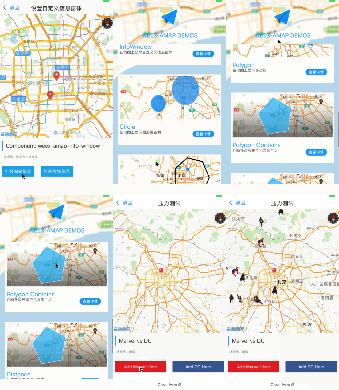
ios demo 如下所示

如何将地图插件集成到自己的项目呢,请参考weexpack文档说明
FAQs
weex mapview component
We found that weex-amap demonstrated a not healthy version release cadence and project activity because the last version was released a year ago. It has 1 open source maintainer collaborating on the project.
Did you know?

Socket for GitHub automatically highlights issues in each pull request and monitors the health of all your open source dependencies. Discover the contents of your packages and block harmful activity before you install or update your dependencies.

Security News
Critics call the Node.js EOL CVE a misuse of the system, sparking debate over CVE standards and the growing noise in vulnerability databases.

Security News
cURL and Go security teams are publicly rejecting CVSS as flawed for assessing vulnerabilities and are calling for more accurate, context-aware approaches.

Security News
Bun 1.2 enhances its JavaScript runtime with 90% Node.js compatibility, built-in S3 and Postgres support, HTML Imports, and faster, cloud-first performance.