Product
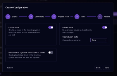
Socket for Jira Is Now Available
Socket for Jira lets teams turn alerts into Jira tickets with manual creation, automated ticketing rules, and two-way sync.
By Jeppe Hasseriis - Apr 20, 2026
world-atlas
Advanced tools
This repository provides a convenient redistribution of Natural Earth’s vector data, version 4.1.0 as TopoJSON. For earlier editions, see past releases.
In a browser, using d3-geo and Canvas:
https://observablehq.com/@d3/world-map
In a browser, using d3-geo and SVG:
https://observablehq.com/@d3/world-map-svg
In Node, using d3-geo and node-canvas:
https://bl.ocks.org/mbostock/885fffe88d72b2a25c090e0bbbef382f
# countries-110m.json · Download
A TopoJSON file containing the geometry collections countries and land. The geometry is quantized, but not projected; it is in spherical coordinates, decimal degrees. This topology is derived from the Natural Earth’s Admin 0 country boundaries, 1:110m small scale. The land boundary is computed by merging countries, ensuring a consistent topology.
# countries-50m.json · Download
A TopoJSON file containing the geometry collections countries and land. The geometry is quantized, but not projected; it is in spherical coordinates, decimal degrees. This topology is derived from the Natural Earth’s Admin 0 country boundaries, 1:50m medium scale. The land boundary is computed by merging countries, ensuring a consistent topology.
# countries-10m.json · Download
A TopoJSON file containing the geometry collections countries and land. The geometry is quantized, but not projected; it is in spherical coordinates, decimal degrees. This topology is derived from the Natural Earth’s Admin 0 country boundaries, 1:10m large scale. The land boundary is computed by merging countries, ensuring a consistent topology.
A TopoJSON file containing the geometry collection land. The geometry is quantized, but not projected; it is in spherical coordinates, decimal degrees. This topology is derived from the Natural Earth’s land boundaries, 1:110m small scale.
A TopoJSON file containing the geometry collection land. The geometry is quantized, but not projected; it is in spherical coordinates, decimal degrees. This topology is derived from the Natural Earth’s land boundaries, 1:50m medium scale.
A TopoJSON file containing the geometry collection land. The geometry is quantized, but not projected; it is in spherical coordinates, decimal degrees. This topology is derived from the Natural Earth’s land boundaries, 1:10m large scale.
# world.objects.countries
Each country has two fields:
"528""Netherlands"# world.objects.land
FAQs
Pre-built TopoJSON from Natural Earth.
We found that world-atlas demonstrated a not healthy version release cadence and project activity because the last version was released a year ago. It has 1 open source maintainer collaborating on the project.
Did you know?

Socket for GitHub automatically highlights issues in each pull request and monitors the health of all your open source dependencies. Discover the contents of your packages and block harmful activity before you install or update your dependencies.
Product
Socket for Jira lets teams turn alerts into Jira tickets with manual creation, automated ticketing rules, and two-way sync.
Company News
Socket won two 2026 Reppy Awards from RepVue, ranking in the top 5% of all sales orgs. AE Alexandra Lister shares what it's like to grow a sales career here.

Security News
NIST will stop enriching most CVEs under a new risk-based model, narrowing the NVD's scope as vulnerability submissions continue to surge.