Security News
Research
Data Theft Repackaged: A Case Study in Malicious Wrapper Packages on npm
The Socket Research Team breaks down a malicious wrapper package that uses obfuscation to harvest credentials and exfiltrate sensitive data.
Census Geocode is a light weight Python wrapper for the US Census Geocoder API, compatible with Python 3. It comes packaged with a simple command line tool for geocoding an address to a longitude and latitude, or a batch file into a parsed address and coordinates.
It's strongly recommended to review the Census Geocoder docs before using this module.
Basic example:
import censusgeocode as cg
cg.coordinates(x=-76, y=41)
cg.onelineaddress('1600 Pennsylvania Avenue, Washington, DC')
cg.address('1600 Pennsylvania Avenue', city='Washington', state='DC', zip='20006')
cg.addressbatch('data/addresses.csv')
Use the returntype keyword to specify 'locations' or 'geographies'. 'Locations' yields structured information about the address, and 'geographies' yields information about the Census geographies. Geographies is the default.
cg.onelineaddress('1600 Pennsylvania Avenue, Washington, DC', returntype='locations')
Queries return a CensusResult object, which is basically a Python list with an extra 'input' property, which the Census returns to tell you how they interpreted your request.
>>> result = cg.coordinates(x=-76, y=41)
>>> result.input
{
    u'vintage': {
        u'vintageName': u'Current_Current',
        u'id': u'4',
        u'vintageDescription': u'Current Vintage - Current Benchmark',
        u'isDefault': True
    },
    u'benchmark': {
        u'benchmarkName': u'Public_AR_Current',
        u'id': u'4',
        u'isDefault': False,
        u'benchmarkDescription': u'Public Address Ranges - Current Benchmark'
    },
    u'location': {
        u'y': 41.0,
        u'x': -76.0
    }
}
>>> result
[{
    '2010 Census Blocks': [{
        'AREALAND': 1409023,
        'AREAWATER': 0,
        'BASENAME': '1045',
        'BLKGRP': '1',
        'BLOCK': '1045',
        'CENTLAT': '+40.9957436',
        'CENTLON': '-076.0089338',
        'COUNTY': '079',
        'FUNCSTAT': 'S',
        'GEOID': '420792166001045',
        'INTPTLAT': '+40.9957436',
        'INTPTLON': '-076.0089338',
        'LSADC': 'BK',
        'LWBLKTYP': 'L',
        'MTFCC': 'G5040',
        'NAME': 'Block 1045',
        'OBJECTID': 9940449,
        'OID': 210404020212114,
        'STATE': '42',
        'SUFFIX': '',
        'TRACT': '216600'
    }],
    'Census Tracts': [{
        # snip
        'NAME': 'Census Tract 2166',
        'OBJECTID': 61245,
        'OID': 20790277158250,
        'STATE': '42',
        'TRACT': '216600'
    }],
    'Counties': [{
        # snip
        'NAME': 'Luzerne County',
        'OBJECTID': 866,
        'OID': 27590277115518,
        'STATE': '42'
    }],
    'States': [{
        # snip
        'NAME': 'Pennsylvania',
        'REGION': '1',
        'STATE': '42',
        'STATENS': '01779798',
        'STUSAB': 'PA'
    }]
}]
By default, the geocoder uses the "Current" vintage and benchmarks. To use another vintage or benchmark, use the CensusGeocode class:
from censusgeocode import CensusGeocode
cg = CensusGeocode(benchmark='Public_AR_Current', vintage='Census2020_Current')
cg.onelineaddress(foobar)
The Census may update the available benchmarks and vintages. Review the Census Geocoder docs for the currently available benchmarks and vintages.
The censusgeocode tool has two settings.
At the simplest, it takes one argument, an address, and returns a comma-delimited longitude, latitude pair.
censusgeocode '100 Fifth Avenue, New York, NY'
-73.992195,40.73797

censusgeocode '1600 Pennsylvania Avenue, Washington DC'
-77.03535,38.898754
The Census geocoder is reasonably good at recognizing non-standard addresses.
censusgeocode 'Hollywood & Vine, LA, CA'
-118.32668,34.101624
It can also use the Census Geocoder's batch function to process an entire file. The file must be comma-delimited, have no header, and include the following columns:
unique id, street address, state, city, zip code
The geocoder can read from a file:
censusgeocode --csv tests/fixtures/batch.csv
Or from stdin, using - as the filename:
head tests/fixtures/batch.csv | censusgeocode --csv -
According to the Census docs, the batch geocoder is limited to 10,000 rows.
The output will be a CSV file (with a header) and the columns:
If your data doesn't have a unique id, try adding line numbers with the Unix command line utility nl:
nl -s , input.csv | censusgeocode --csv - > output.csv
This program is free software: you can redistribute it and/or modify it under the terms of the GNU General Public License as published by the Free Software Foundation, either version 3 of the License, or (at your option) any later version.
This program is distributed in the hope that it will be useful, but WITHOUT ANY WARRANTY; without even the implied warranty of MERCHANTABILITY or FITNESS FOR A PARTICULAR PURPOSE. See the GNU General Public License for more details.
You should have received a copy of the GNU General Public License along with this program. If not, see http://www.gnu.org/licenses/.
FAQs
Thin Python wrapper for the US Census Geocoder
We found that censusgeocode demonstrated a healthy version release cadence and project activity because the last version was released less than a year ago. It has 1 open source maintainer collaborating on the project.
Did you know?

Socket for GitHub automatically highlights issues in each pull request and monitors the health of all your open source dependencies. Discover the contents of your packages and block harmful activity before you install or update your dependencies.

Security News
Research
The Socket Research Team breaks down a malicious wrapper package that uses obfuscation to harvest credentials and exfiltrate sensitive data.

Research
Security News
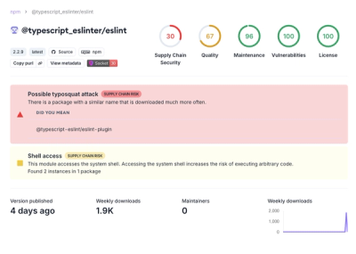
Attackers used a malicious npm package typosquatting a popular ESLint plugin to steal sensitive data, execute commands, and exploit developer systems.

Security News
The Ultralytics' PyPI Package was compromised four times in one weekend through GitHub Actions cache poisoning and failure to rotate previously compromised API tokens.